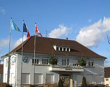
Oberhausbergen
| Oberhausbergen | ||
|---|---|---|

|
|
|
| region | Grand Est | |
| Department | Bas-Rhin | |
| Arrondissement | Strasbourg | |
| Canton | Hœnheim | |
| Community association | Eurométropole de Strasbourg | |
| Coordinates | 48 ° 36 ' N , 7 ° 41' E | |
| height | 143-187 m | |
| surface | 3.79 km 2 | |
| Residents | 5,381 (January 1, 2017) | |
| Population density | 1,420 inhabitants / km 2 | |
| Post Code | 67205 | |
| INSEE code | 67343 | |
| Website | http://www.oberhausbergen.com/ | |
 Protestant Church Oberhausbergen |
||
Oberhausbergen is a French town with 5381 inhabitants (as of January 1, 2017) in the Bas-Rhin department in the Grand Est region ( Alsace until 2015 ). The inhabitants are called Oberhausbergeois (es) or Supradomimontain (ne) s .
geography
OBERHAUSBERGEN is northwest of Strasbourg at the department road D41 between stutzheim-offenheim and Cronenbourg (western district of Strasbourg), at D63 after Wolfisheim and the D563 proposes in the municipality an arc between the other department roads. To the north of Oberhausbergen are Mittelhausbergen and Niederhausbergen , to the south is Wolfisheim, to the west are meadows and fields.
history
Archaeological finds show that hunters and gatherers visited the municipality around 600,000 years ago . It is believed that Neanderthals lived from around 90,000 to 40,000 BC. BC in Oberhausbergen and there are finds from the Neolithic Age (around 5000 BC). In today's Valparc district, dwellings were found that existed from 725 to 450 BC. Were used.
Oberhausbergen was also settled in Gallo-Roman times . An aqueduct ran from Kuttolsheim to Strasbourg and passed Oberhausbergen. In 357 the battle of Argentoratum took place there. Many Roman coins were found in the fields around the city . With the decline of the Roman Empire (from 406) archaeological finds become rare, but these rare finds indicate that the place was also settled in the Merovingian period.
In 763 the city was mentioned for the first time as Hugesperg . At that time it belonged to the Duchy of Swabia . In the 10th century, Bishop Richwin gave Oberhausbergen to the St. Thomas Foundation in Strasbourg.
On March 8, 1262, the troops of Strasbourg bishop Walter von Geroldseck were defeated near Oberhausbergen, who was at war with the citizens of the city.
From the 15th century until the French Revolution , Oberhausbergen was the fief of the Zorn von Plobsheim family .
The community burned down in 1646, but it is not known whether this was a consequence of the Thirty Years War (1618–1648) or an accident.
Before the French Revolution , the village had 290 inhabitants. The Cahiers de Doléances (complaints booklets) from Oberhausbergen are a rarity. Only a few of these booklets have survived in the Bas-Rhin. In 1789 the city council was established. The first mayor of the city was Michel Lobstein. Until 1835 Oberhausbergen was the capital of the canton of the same name.

| year | 1962 | 1968 | 1975 | 1982 | 1990 | 1999 | 2006 | 2013 |
| Residents | 1,291 | 1,818 | 2,103 | 2.014 | 3,020 | 4,518 | 4,397 | 4,855 |
Community partnerships
Since September 2012, Saint-Sauveur-le-Vicomte has been a partner municipality of Oberhausbergen in Normandy.
literature
- Le Patrimoine des Communes du Bas-Rhin . Flohic Editions, Volume 2, Charenton-le-Pont 1999, ISBN 2-84234-055-8 , pp. 846-849.
