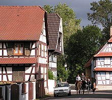
Souffelweyersheim
| Souffelweyersheim | ||
|---|---|---|

|
|
|
| region | Grand Est | |
| Department | Bas-Rhin | |
| Arrondissement | Strasbourg | |
| Canton | Hœnheim | |
| Community association | Eurométropole de Strasbourg | |
| Coordinates | 48 ° 38 ' N , 7 ° 44' E | |
| height | 133-153 m | |
| surface | 4.51 km 2 | |
| Residents | 8,001 (January 1, 2017) | |
| Population density | 1,774 inhabitants / km 2 | |
| Post Code | 67460 | |
| INSEE code | 67471 | |
| Website | www.ville-souffelweyersheim.fr | |
Souffelweyersheim (German Suffelweyersheim ) is a French commune with 8001 inhabitants (as of January 1, 2017) in the Bas-Rhin department in the Grand Est region (until 2015 Alsace ).
geography
Souffelweyersheim is located in the Upper Rhine Plain between the Vosges and the Rhine , about six kilometers north of Strasbourg , between Mundolsheim and Schiltigheim and on the A4 autoroute , the closest connection to which is No. 49 - Reichstett . The Souffel , a river that flows into the Ill, flows through the village .
Neighboring communities are (clockwise from the north) Reichstett , Hœnheim , Niederhausbergen and Mundolsheim.
history
The place was first mentioned in 1156 under the name Wickersheim. Since it was often confused with the nearby Weyersheim today , it was given the addition of the name of the river, so that it is known under its current name from 1285. Probably he belonged to the sphere of influence of the diocese of Strasbourg .
The village suffered greatly from the Thirty Years' War , and its residents left it at times.
The 18th century was a relatively peaceful period during which the new Saint-Georges church was built in neoclassical style , of which the lower part of the tower with the date 1781 is still preserved today.
Souffelweyersheim was also badly affected during the French Revolution , but especially during the Wars of Liberation at the end of Napoleon's reign : On June 29, 1815, it was completely burned down and many residents were killed. Many half-timbered houses were rebuilt by 1820, the church was rebuilt in 1820, and the remaining tower stump was increased in 1827.
After 1870 the community was included in the defenses of Strasbourg, remnants of which can still be seen in the area.
At the beginning of the 20th century, the place was still predominantly agricultural, but industrialization in the north of Strasbourg brought a strong increase in population because of the jobs in the area (railway depot in Bischheim , marshalling yard in Niederhausbergen ). In the 1960s there was a new impetus through the admission into the city association of Strasbourg, the municipality also became important as a residential municipality for Strasbourg. Since 2000 there has also been a connection to the Strasbourg tram (line B) in neighboring Hœnheim .
| year | 1962 | 1968 | 1975 | 1982 | 1990 | 1999 | 2006 | 2013 |
|---|---|---|---|---|---|---|---|---|
| Residents | 2,750 | 3,144 | 3,978 | 4.012 | 5,591 | 6,017 | 6.219 | 7,665 |
Sources: INSEE
Others
A locomotive class BB 26000 of the National French railways (SNCF) is named after the town of Souffelweyersheim.
literature
- Le Patrimoine des Communes du Bas-Rhin . Flohic Editions, Volume 2, Charenton-le-Pont 1999, ISBN 2-84234-055-8 , pp. 856-861.
Individual evidence
- ↑ ( Page no longer available , search in web archives: PDF )


