Großheinrichschlag
|
Großheinrichschlag ( village ) locality |
||
|---|---|---|
|
|
||
| Basic data | ||
| Pole. District , state | Krems-Land (KR), Lower Austria | |
| Judicial district | Krems at the Donau | |
| Pole. local community | Weinzierl am Walde ( KG Großheinrichschlag) | |
| Coordinates | 48 ° 25 '8 " N , 15 ° 22' 59" E | |
| height | 705 m above sea level A. | |
| Residents of the village | 147 (January 1, 2020) | |
| Statistical identification | ||
| Locality code | 04224 | |
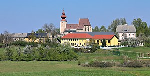
 South view of Sankt Johann, a church hamlet in Großheinrichschlag |
||
| Source: STAT : index of places ; BEV : GEONAM ; NÖGIS | ||
Großheinrichschlag is a village in the municipality of Weinzierl am Walde in Lower Austria .
The place is located southwest of Weinzierl and on the south side of the deeply cut Kremstal , on the opposite side of which Kleinheinrichschlag is located. Until the end of 1969, Großheinrichschlag formed an independent municipality together with the localities of Habruck and Lobendorf and joined the municipality of Weinzierl on January 1, 1972.
Individual evidence
- ↑ Großheinrichschlag on weinzierl-walde.gv.at

