Wilhelminenzeche mine
| Wilhelminenzeche mine | |||
|---|---|---|---|
| General information about the mine | |||
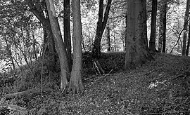
| Pinge of the air shaft that had been sunk to ventilate the Wilhelminen tunnel below. It is a registered ground monument . | |||
| Information about the mining company | |||
| Start of operation | 1848 | ||
| End of operation | unknown | ||
| Funded raw materials | |||
| Degradation of | Calamine | ||
| Geographical location | |||
| Coordinates | 50 ° 59 '47.1 " N , 7 ° 11' 12.3" E | ||
|
|||
| Location | Men's rounds | ||
| local community | Bergisch Gladbach | ||
| District ( NUTS3 ) | Rheinisch-Bergischer Kreis | ||
| country | State of North Rhine-Westphalia | ||
| Country | Germany | ||
| District | Bensberg ore district | ||
The pit Wilhelmine Colliery is a former calamine -Grube of Bensberger Erzreviers in Bergisch Gladbach . The site belongs to the Herrenstrunden district .
history
Due to a Mutungssgesuchs of 2 March 1848, took place ceremony of the mining area on 19 October 1848 calamine . The district court of Bensberg determined on October 16, 1903 that evidence of a deposit worth building had not been provided. An annual report on the operation of the Wilhelminenzeche mine mentions two workers for 1905 and shows the following text: "The tunnel has been opened up and used by the owner, the JW Zanders paper mill in Bergisch Gladbach, for a water extraction system." A Melusina union Essen-Steele obviously had money claims from the previous owner, the Hohenstaufen zu Essen union, and asked the Deutz mining district about the ownership of a steam boiler on the Wilhelminenzeche. The mining district replied on July 17, 1906 that the steam boiler No. 311 had been relocated to the Westig shaft in the Witten mining association in 1897 . The files were handed over to the responsible mining district official on March 3, 1897 . Accordingly, operational activities should have taken place by the end of the 19th century. Beyond that, there is no information about operational activities.
Location and relics
The Wilhelminenzeche is located about 300 m west of Bech and about 300 m northeast of Breitenweg on a slope that slopes to the northwest. You can see a pinge with a diameter of about 20 m. It is very well preserved and was listed as ground monument no. 14, but not protected (see photo). Below is a quarry. The Wilhelminen tunnel must have been in this area.
Individual evidence
- ^ Herbert Stahl (editor), Gerhard Geurts , Hans-Dieter Hilden, Herbert Ommer : Das Erbe des Erzes. Volume 3: The pits in the Paffrath Kalkmulde. Bergischer Geschichtsverein Rhein-Berg, Bergisch Gladbach 2006, ISBN 3-932326-49-0 , p. 89ff. ( Series of publications by the Bergisches Geschichtsverein Rhein-Berg eV 49).

