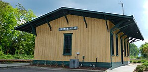
Guntersville
| Guntersville | |
|---|---|
 Guntersville Hydroelectric Project on Lake Guntersville |
|
| Location in County and Alabama | |
| Basic data | |
| State : | United States |
| State : | Alabama |
| County : | Marshall County |
| Coordinates : | 34 ° 21 ′ N , 86 ° 18 ′ W |
| Time zone : | Central ( UTC − 6 / −5 ) |
| Residents : | 8,197 (as of 2010) |
| Population density : | 124.6 inhabitants per km 2 |
| Area : | 109.9 km 2 (approx. 42 mi 2 ) of which 65.8 km 2 (approx. 25 mi 2 ) is land |
| Height : | 198 m |
| Postal code : | 35976 |
| Area code : | +1 256 |
| FIPS : | 01-32416 |
| GNIS ID : | 0157977 |
| Website : | www.guntersvilleal.org |
 Railway Station Museum (2012) |
|
Guntersville is a city with almost 10,000 inhabitants and the administrative seat in Marshall County , Alabama , USA.
It is located at the end of Alabama State Route 69 , on the south bank of Alabama's largest lake, Lake Guntersville, a reservoir of the Tennessee River , about 50 km southeast of Huntsville and about 10 km northwest of Albertville .
The city was founded by its namesake John Gunter (1765–1835) in the late 18th century.
Eight structures and sites in Guntersville are listed on the National Register of Historic Places as of December 7, 2019, including the Guntersville Hydroelectric Project and the Downtown Guntersville Historic District .
Personalities
- Joe Starnes (1895–1962), politician
Remarks
-
↑ Search mask database in the National Register Information System. National Park Service , accessed December 7, 2019.
Weekly List on the National Register Information System. National Park Service , accessed December 7, 2019.
