Gwembe
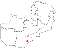
Gwembe is a place above the slope to Kariba Dam in the Southern Province in Zambia . It is 1,216 meters above sea level and is the seat of the administration of the district of the same name with 34,133 inhabitants (2000 census). The place is 50 kilometers south of Monze on a small reservoir.
economy
Like Siavonga , Sinazongwe , Binga , Siabuwa , Gwembe is a place for resettled Tonga. Today they live on the heights where the soils are more barren than in the valley floor, where they lived secluded in the Zambezi River before the Kariba Dam was flooded, where high, vertical rock walls made any contact with the outside world almost impossible. It is subsistence farming operates on a simple level in semiarid area. The share of market sales is limited to the acute need for money. Churn is high. The houses are made of clay and covered with grass. There is no power grid in the district outside of Gwembe town. Drinking water comes from rivers, lakes or shallow boreholes and is of poor quality. Some development projects have spread wickerwork made from palm leaves, which are sold as far as Europe.
tourism
There is safari tourism including hunting on Lake Kariba.
Infrastructure
The paved road to Monze is about 30 kilometers away. There is an unpaved, 1,000 meter long runway, a hospital and primary schools. The place is connected to the national power grid.
Social
The dominant tribe are the Tonga.
See also
- For a map with all districts and provinces see: Administrative division of Zambia
Web links
- Photos of the Gwembe Valley
- Gwembe Tonga Research Project (English)
- Life as a Subsistence farmers: the Gwembe Tonga Simulation (English)
Coordinates: 16 ° 30 ′ S , 27 ° 36 ′ E
