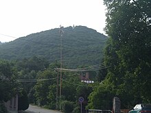
Velem-Szentvid hilltop settlement
The hill settlement Velem-Szentvid is a Latène period settlement on the Sankt Vitusberg ( Szentvid-hegyi ) in the Hungarian city of Velem (German: St. Vitus in Vas County ), 6 km southwest of Kőszeg (Güns) in the Günser Mountains ( Kőszegi- hegység ). The place is in the area of the Geschrittenstein-Írottkő Nature Park .
Velem-Szentvid has been settled since the Neolithic (Neolithic; 5500 to 2200 BC), was a center of bronze production and processing in the late Bronze Age (1300 to 800 BC) and finally in the Latène period (480 BC). Until around the birth of Christ) an important European iron trading center. Velem-Szentvid was probably closely connected with the settlements of Sopron-Várhely (Hungary) and Burg in Schwarzenbach ( Lower Austria ) at the same time . The presence of the Celts since the early La Tène period is confirmed by individual finds, the oppidum (fortified, urban-like settlement) was founded in the late La Tène period.
Excavation history
Excavations have been taking place on St. Vitus Hill since 1896, initially at the instigation of Kálmán Miske, who had already kept some objects in his prehistoric private collection. These excavations exposed a hilltop settlement that Miske wanted to present in a series of books on science; only the first volume on surface finds has appeared. These first excavations ended in 1929.
New excavations from 1972 to 1985 were carried out on behalf of the Savaria Museum in Szombathely (Ger. Steinamanger), especially in the time horizon of the late Bronze Age settlement; a Franco-Hungarian excavation campaign between 1988 and 1994 dealt with the settlement in the late Làtene period.
The importance of the settlement for the Celtic Oppida culture was equated by Joseph Déchelette with Bibracte on Mont Beuvray in France , as well as the Oppida von Manching in Bavaria , Heidetränk im Taunus ( Hesse ) and Stradonice in the Czech Republic , which in his opinion represent the unity of the celtic world show.
Archaeological finds
Fortifications
The ramparts cover an area of around 30 hectares and are oval-shaped in a north-west-south-east orientation. This complex west of the church on Sankt-Vitusberg is best preserved. The entire upper town of the oppidum is bordered by the ramparts, in the east there was probably a gate system that opened to the plain dominated by the settlement. A possible second gate in the west into the upper town was destroyed by the brisk medieval building activity on the mountain plateau. Two fortification walls from Celtic times have been excavated from this presumed gate in the direction of the pass that connects the Sankt-Vitusberg with the Günser Mountains. It is no longer possible to determine with certainty whether they protected a “suburb”.
One of the walls has been shown to consist of a beam structure as the inner framework of the infill as well as an outer and inner wall facing made of dry stone (facing walls), an important research result for the Oppida facilities in Central and Eastern Europe.
Settlement
The area within the walls shows that in the Latène period some smaller terraces were merged into one large one by leveling. The original level of this Latène terrace has been significantly changed by erosion and subsequent earthworks. The actual oppidum is dated to the LT D1 period (late La Tène period; 190 BC to the birth of Christ). Ceramic finds from this Celtic period prove the dating, a later further use of the oppidum is to be assumed; when it was abandoned has not yet been determined. The inhabitants of the Boier people were resettled by the Romans in Savaria, founded by Emperor Claudius .
The rich metal finds (bronze jewelry, iron tools), which are typical of oppida cultures, come from older excavations. The mostly unpainted ceramic goods correspond to East Celtic tradition. The most important found objects are kept in the Savaria Museum Szombathely and in the Natural History Museum Vienna .
A localization of the surely existing burial ground of the oppidum was not yet successful until 2012.
Coin Treasure Finds
In 1899 a Celtic coin treasure was found in a clay pot on Sankt-Vitusberg. It consisted of several coins of the Velem type with different coinage. Kálmán Miske also discovered several individual coins, including 13 Velem, 2 Noric , 3 Boische, as well as some small silver coins of local minting. In terms of style, style and weight, the find dates back to the first half of the 1st century BC. To date. The clay pot was lost, eleven of the coins were resold by the Hungarian National Museum .
See also
literature
- Stephan Foltiny: Velemszentvid, a primeval cultural center in Central Europe. Publications by the Austrian Working Group on Prehistory III, Prehistory Institute of the University of Vienna, 1958.
- Susanne Sievers , Otto H. Urban , Peter C. Ramsl: Lexicon for Celtic Archeology. L-Z. In: Communications from the Prehistoric Commission. Volume 73. Verlag der Österreichischen Akademie der Wissenschaften, Vienna 2012, ISBN 978-3-7001-6765-5 , pp. 1914 ff.
- Melinda Torbágyi: Two Celtic coin treasures in the Hungarian National Museum (Velem-Szentvid and Ostffyasszonyfa). Folia Archaeologica 49-50, Verlag Népművelési Propaganda Iroda, Budapest 2001/02, p. 143 ff.
Individual evidence
- ^ Kálmán Miske: The prehistoric settlement Velem-St.Vid. 1st volume, Vienna 1908.
- ^ Jean-Paul Guillaumet, Miklós Szabó, Zoltan Czajlik: Bilan des recherches franco-hongroises à Velem-Szentvid (1988–1994). Savaria 24/3, 1998/99, p. 193 ff.
- ↑ Oppida celtiques, atlas des fortifications , with a map, accessed on September 8, 2013.
- ↑ Alphons Augustinus Barb: A Celtic coin find from Burgenland. Numismatic magazine 21, Vienna 1928, p. 20 ff.
- ↑ Hanns Schmid: Prehistory-Roman Age-Middle Ages, materials on archeology and regional studies of Burgenland. Volume 1. Burgenland State Museum, 1984, ISBN 9783-8540-5091-9; P. 74. from books.google.ch, accessed on September 8, 2013.
Coordinates: 47 ° 21 '8.9 " N , 16 ° 28' 36.1" E
