
High stones
| High stones | ||
|---|---|---|
 Map of the high stones |
||
| height | 235.7 m above sea level NHN (not exactly measured highest point is just over 240 m high) | |
| location | Eitorf | |
| Mountains | Leuscheid | |
| Coordinates | 50 ° 45 '34 " N , 7 ° 27' 59" E | |
|
||

An elevation in Eitorf is called Höhensteine . It is one of the northwestern foothills of the Leuscheid . Its height is a good 240 m above sea level. NHN .
The height of stones, known locally as the height of stone called, have their name from large quartz boulders, in the humus layer are embedded.
location
The Höhensteine are limited by the Sterzenbach and Altebach in the northeast, the Pingelsbach and Dehlenbach in the southwest, the Eipbach in the west and the Sieg in the north. In the southeast the Höhensteine have a connection with the Käsberg to Eitorfer Schweiz and Leuscheid .
The foothills of the Höhensteine are in Eitorf the Leienberg , east of the Silbersiefen the Maiberg and Huckenbröl as well as the Nennsberg in Bitze and south of the Weingartssiefens the Ommersberg .
vegetation
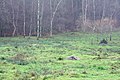
Covered the amount of stones pines - and oak nwald with hardly ever encountered Ilex Undergrowth, blueberries and heather , on the slopes is pasture operated business.
Others
Main hiking trail 2 (Eitorf - Neuwied ) of the Westerwald Association leads over the Höhensteine . At the top of the hill there is a pavilion built on a foundation of coarse quartz gravel . A panoramic view is no longer given due to the tall trees. In addition to the pavilion a radio mast is built for the mobile nets D1 , E-Plus , O₂ and Vodafone .
Quartz chunks on the high stones

Quartz chunks in the pastures above Huckenbröl
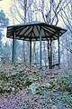
Höhensteine pavilion
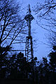
The Huckenbröl cell tower


