Hünerberg (Taunus)
| Hünerberg | ||
|---|---|---|
|
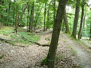
Early medieval ring wall on the Hünerberg |
||
| height | 375 m | |
| location | Hessen , Germany | |
| Mountains | Taunus | |
| Coordinates | 50 ° 12 '3 " N , 8 ° 31' 2" E | |
|
|
||
The Hünerberg is a 375 meter high elevation between Falkenstein and Oberursel . The Hünerberg ring wall is located on the mountain . Finds unearthed there indicate that this is a fortification from the Carolingian period (8th or 9th century AD). Further artifacts come from the Urnfield Period , Hallstatt Period and Roman Period . It has not yet been proven whether a mountain fortification existed earlier.
A face of the mountain is as Hünerbergwiesen of Oberursel been instructed Nature Reserve .
See also
literature
- F.-R. Herrmann, Archaeological Monuments in Hessen, Issue 44, The ring wall on the Hünerberg in the Taunus. Leaflet for the early medieval castle near Kronberg-Oberhöchstadt, Hochtaunuskreis (1985, 2nd supplementary edition in preparation). 8 p., 5 ills., Color plan in the scale 1: 2500. ISBN 389822-044-3
- F. Schummer, communications from the Association for History and Local History Oberursel / Taunus eV, issue 20-1976, New Finds on Ringwall Hünerberg im Taunus , 1976
Individual evidence
- ^ Römisch-Germanisches Zentralmuseum Mainz, Guide to prehistoric and early historical monuments, Volume 21, Hochtaunus - Bad Homburg - Usingen - Königstein - Hofheim , Verlag Philipp von Zabern , Mainz 1972, p. 218

