
Hammersee (Juist)
| Hammersee (Juist) | ||
|---|---|---|

|
||
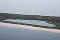
| Hammersee with dunes in the background, September 2010 | ||
| Geographical location | East Frisian Islands: Juist , Aurich district , Lower Saxony | |
| Places on the shore | Loog (Juist) | |
| Data | ||
| Coordinates | 53 ° 40 ′ 29 " N , 6 ° 56 ′ 35" E | |
|
||
| Altitude above sea level | 0 m above sea level NHN | |
| surface | 17 ha | |
| Middle deep | 1 m | |
|
particularities |
Residual sea of a storm surge |
|

|
||

The Hammersee is an inland lake that was created in 1932 by a storm surge on the East Frisian island of Juist , which is located in the Aurich district in Lower Saxony .
It is the largest freshwater lake on a North Sea island. The inland water is found in the western third of the long, narrow island body. The name of the lake indicates its origin. "Hammer", from the East Frisian word "Hamrig", is a shared pasture area.
The lake was created by flooding such a hamrig pasture.
As a result of the Petri flood of 1651, the island was initially divided into two parts. Around the year 1770 work began on filling up the approximately two kilometer wide breakthrough first on the south side, which was completed in 1877. It was not until 1928 that the north side facing the sea was closed with a sand dam. During a storm surge in 1932, the water broke through the northern dike, flooded the area behind it and no longer drained.
Over time, the salt content in Hammersee decreased - today it is a slightly brackish freshwater lake with reed beds , surrounded by chains of dunes. The Hammersee is subject to constant siltation . The wind also brings in sand from the northwest.
Otto Leege , first commissioner for nature conservation in East Friesland and pioneer of sustainable bird and island protection, began in the 1920s to plant particularly hardy plants west of the Hammersee, thus creating the nucleus of today's (barren) tree population and the nature reserve around around the Hammersee. It is an important feeding and resting area for insects and birds. Due to the surrounding forest and reed belt, the Hammersee is a relatively undisturbed area with a rich supply of food and, above all, fresh water. It is only accessible to people in a few places. Today's open water area is 17.3 hectares; including the silting zones, the wetland covers over 35 hectares. The average depth of the lake is around one meter.
Picture gallery
Hammersee from above

Hammersee with riparian vegetation, September 2010
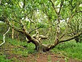
Crooked birch in the NSG on the edge of the lake
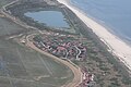
Hammersee with the neighboring Loog settlement, July 2010


See also
Web links
Individual evidence
- ↑ Information board on and about the Otto-Leege-Path, Juist, National Park Management Lower Saxony Wadden Sea [as of October 2017]
- ^ Rolf Niedringhaus: The flora and fauna of the East Frisian Islands - Juist . Carl von Ossietzky University. March 10, 2011. Retrieved September 21, 2014.