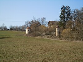
Hammetweil
|
Hammetweil
community Neckartenzlingen
Coordinates: 48 ° 34 '23 " N , 9 ° 13' 26" E
|
|
|---|---|
| Height : | approx. 330 m above sea level NHN |
| Postal code : | 72654 |
| Area code : | 07127 |
|
Hammetweil 2019
|
|
Hammetweil is an estate belonging to the municipality of Neckartenzlingen in the Esslingen district in Baden-Württemberg .
geography
Hammetweil is about two kilometers southwest of the village center of Neckartenzlingen at about 330 m above sea level. NHN on the northwest slope of the Neckar valley .
On the valley side of the outskirts, the Hammetweiler Graben arises , which runs down the slope, crosses the broad floodplain of the river on the left and flows into the Neckar from the left after a total of 0.6 km approximately to the east . On the mountain side, the Hammetweil golf course is directly adjacent to the Hofgut.
history
Hammetweil Castle was first mentioned in 1266 as Nohmuotwiler , it was probably built around that time by the Lords of Hammetweil, knightly servants of the Counts of Hohenberg . In the 14th century, the castle was given to the lords of Zimmer as a fief , who then called themselves Zimmerer von Hammetweil. After their extinction at the end of the 15th century, Hammetweil belonged to Austria as a Hohenberg fief . Then the manor passed through different hands until 1543 the Württemberg hereditary marshal Hans Konrad Thumb von Neuburg acquired it for 3,100 florins . Since then, the estate has been owned by the von Thumb barons . Until 1805 as an Austrian fiefdom, from 1806 to 1866 as a man fief of the Crown Württemberg, since then as property.
During the Thirty Years War , the manor was uninhabited for several years. The drawing in Kieser's forest inventory book shows the stone house of the medieval castle complex, i.e. the residential building of the castle. In addition, a wall tower and parts of the wall. The stone house was demolished in 1821 due to its disrepair. Two round towers connected by a wall on the side of the Neckar valley are still preserved today as the remains of the former fortifications. Extensive structural changes were made in the 1860s. A tenant house was built in the Swiss style. The old house was demolished and the elongated stable building was built on the valley side in its place. Horse farming has been practiced on the farm for several decades.
A golf course with 18 holes has been located on part of the estate since 2005.
Religions
The residents of Hammetweil are supported by the Ev. Pfarramt Mittelstadt looks after and thus, like Mittelstadt, belongs to the Urach church district. There is a former chapel in the Hammetweil area. Neckartenzlingen, on the other hand, belongs to the Nürtingen church district.
traffic
A private road leads to Hammetweil, which branches off from the B 297 running below in the left valley floodplain of the Neckar . The next bus stops are in Neckartenzlingen and Mittelstadt.
literature
- Fritz Reiff: Neckartenzlingen then and now, a home book. - Ed. By the community of Neckartenzlingen, 1959, pp. 168–172
- Hans Schwenkel: Home book of the Nürtingen district. Volume 2. Würzburg 1953, pp. 642-644
- The district of Esslingen - published by the Baden-Württemberg State Archives. V. with the district of Esslingen, Jan Thorbecke Verlag, Ostfildern 2009, ISBN 978-3-7995-0842-1 , volume 2, page 201

