Harkema
 flag |
 coat of arms |
| province |
|
| local community |
|
|
Area - land - water |
6.53 km 2 6.51 km 2 0.02 km 2 |
| Residents | 4,290 (Jan 1, 2017) |
| Coordinates | 53 ° 11 ′ N , 6 ° 8 ′ E |
| Important traffic route |
|
| prefix | 0512 |
| Postcodes | 9207, 9231, 9233, 9261, 9281, 9283-9284, 9289 |
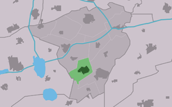
| Location of Harkema in the municipality of Achtkarspelen | |
Harkema ( West Frisian De Harkema ) is a place in the municipality of Achtkarspelen in the east of the Dutch province of Friesland . It had 4,290 inhabitants on January 1, 2017. Until January 1, 1972 the place was called Harkema-Opeinde.
Population development
|
Sports
There are two football clubs in Harkema: Harkemase Boys and vv Harkema-Opeinde . Harkemase Boys played in the Dutch top class in the 2010/2011 season .
people
- The cyclist Pieter Weening was born in Harkema.
Web links
Commons : Harkema - collection of images, videos and audio files
Individual evidence
- ↑ a b Kerncijfers wijken en buurten 2017 Centraal Bureau voor de Statistiek , accessed on June 13, 2018 (Dutch)
