
Harlem River
| Harlem River | ||
 History map |
||
| Data | ||
| location | New York City | |
| source | Hudson River Estuary 40 ° 52 ′ 43 " N , 73 ° 55 ′ 28" W. |
|
| muzzle | East River Estuary Coordinates: 40 ° 46 ′ 49 ″ N , 73 ° 56 ′ 21 ″ W 40 ° 46 ′ 49 ″ N , 73 ° 56 ′ 21 ″ W.
|
|

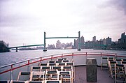
The Harlem River is an estuary in New York City , USA , which stretches for eight miles between the East River and the Hudson River with an average width of 120 meters . The Harlem River inlet separates Manhattan Island from the Bronx , New York's only borough on the American mainland . Part of the current course of the inlet are the Harlem River Ship Canal and the Spuyten Duyvil Creek , which run south of the former waterbed, with the result that Marble Hill , formerly part of Manhattan Island, is now on the northern side of the inlet.
Fifteen bridges span the Harlem River. The banks of the Harlem River are partly designed as recreational areas and small parks; the expanse of water gives the otherwise not very varied district its own charm. Columbia University's rowing club practices regularly on the Harlem and Hudson rivers and uses a dock near 218th Street, between the Harlem River and Spuyten Duyvil Creek, which connects the Harlem River with the Hudson River.
Despite the name, the Harlem River is not a river.
The bridges over the Harlem River
- Wards Island Bridge, also: 103rd Street Footbridge (1951)
- Harlem River lift bridge as a separate part of the Robert F. Kennedy Memorial Bridge (until November 2008: Triborough Bridge) (1936)
- Willis Avenue Bridge (1901)
- Third Avenue Bridge (1898)
- Park Avenue Bridge (Metro-North Railroad) (1956)
- Madison Avenue Bridge (1910)
- 145th Street Bridge (1905)
- Macombs Dam Bridge (1895)
- High Bridge , formerly: Aqueduct Bridge (1848)
- Alexander Hamilton Bridge (I-95 / US 1) (1963)
- Washington Bridge (1888)
- University Heights Bridge (1908)
- Broadway Bridge , also: Harlem Ship Canal Bridge (US 9 with subway no. 1-9 upwards) (1962)
- Henry Hudson Bridge (Henry Hudson Parkway / Route 9A) (1936)
- Sputyen Duyvil Bridge (Amtrak's Empire Corridor) (1900)
See also
gallery
Wards Island Bridge as seen from the northeast
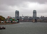
Harlem River Lift Bridge (part of the Robert F. Kennedy Bridge)

Spuyten Duyvil Swing Bridge at the inlet from Spuyten Duyvil Creek into the Hudson River
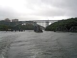
Spuyten Duyvil Swing Bridge and Henry Hudson Bridge as seen from the Hudson River (September 2010)
.jpg)
.jpg)
.jpg)
.jpg)
Web links