Harlowton
| Harlowton | |
|---|---|
 Harlowton Main Street |
|
| Location in Montana | |
| Basic data | |
| Foundation : | 1900 |
| State : | United States |
| State : | Montana |
| County : | Wheatland County |
| Coordinates : | 46 ° 26 ′ N , 109 ° 50 ′ W |
| Time zone : | Mountain ( UTC − 7 / −6 ) |
| Residents : | 997 (as of 2010) |
| Population density : | 664.7 inhabitants per km 2 |
| Area : | 1.50 km 2 (approx. 1 mi 2 ) of which 1.50 km 2 (approx. 1 mi 2 ) is land |
| Height : | 1279 m |
| Postal code : | 59036 |
| Area code : | +1 406 |
| FIPS : | 30-34450 |
| GNIS ID : | 0772154 |
| Mayor : | Tim Cavanaugh |
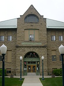
Harlowton is a small town in the US state of Montana . The Wheatland County's administrative seat was founded in 1900 as a train station and is named after the President of the Montana Railroad , Richard A. Harlow.
geography
Harlowton is located in central Montana on the slopes of the Crazy Mountains . Other mountain ranges in the area are the Big Snowy Mountains, the Little Belt Mountains, the Bull Mountains and the Castle Mountains. The urban area has a size of 1.5 km².
In 2010 the population was 997.
Web links
Commons : Harlowton - collection of images, videos and audio files
Individual evidence
- ↑ Central Montana Resource Conservation & Development ( Memento of the original from May 18, 2012 in the Internet Archive ) Info: The archive link was automatically inserted and not yet checked. Please check the original and archive link according to the instructions and then remove this notice. (English)
- ↑ United States Census Bureau (English)

