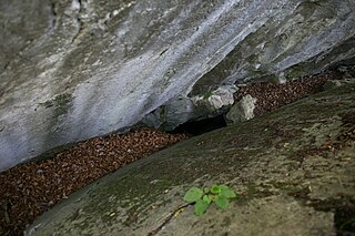
Armor cavity
| Armor cavity
|
||
|---|---|---|
| Location: | Kugelstein near Frohnleiten , Styria / A | |
| Height : | 474 m above sea level A. | |
|
Geographic location: |
47 ° 13 '37.1 " N , 15 ° 20' 5.6" E | |
|
|
||
| Cadastral number: | 2784/24 | |
| Geology: | Schöcklkalk | |
| Lighting: | No | |
| Overall length: | 10 m | |
| Level difference: | -6 m | |
The Harnischhöhle at Frohnleiten is 474 m above sea level. A. im Kugelstein north of the main town of Deutschfeistritz and southwest of Badl , Styria in Austria .
location
The Harnischhöhle is located in the western part of the northern slope of the globular stone, around 18 meters south above the layer boundary cave and west above the large overhang .
description
The approximately 10 meter long armor cave has two entrances or day openings. From the 6.7 meter wide and 1.3 meter high main entrance, a slab of stone , which has been torn apart , leads to a corridor leading to the northwest. This corridor descends steeply and ends at a second, impassable day opening, through which daylight enters the corridor.
The cave floor is largely covered with earthy and loamy sediments and in places with leaves. At the deepest point of the cave passage one can also find fall material.
swell
- Heinrich Kusch : The caves in Kugelstein near Peggau (Styria) . In: The cave . tape 023 , 1972, p. 145–157 ( PDF (4.3 MB) on ZOBODAT ).

