Heidenkopf (Vosges)
| Heidenkopf | ||
|---|---|---|
|
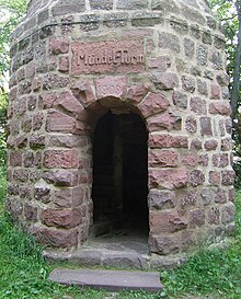
The ward tower on the Heidenkopf |
||
| height | 787 m | |
| location | Lower Alsace , Alsace , France | |
| Mountains | Vosges | |
| Coordinates | 48 ° 28 '10 " N , 7 ° 22' 15" E | |
|
|
||
The Heidenkopf ( 787 m ) lies between the valley of the Magel and the Odilienberg west of Klingenthal near Ottrott in Lower Alsace in the Vosges Mountains . On its summit there are the remains of a documented fortification which, contrary to earlier assumptions, is not of prehistoric but of medieval origin. The castle complex , which dates back to the late 13th or early 14th century, was probably destroyed by bombing before it was completed .
In the middle of the castle stables , the Vosges Club built the 17 m high Mündel Tower in 1909, a lookout tower named after Curt Mündel , the honorary president of the Vosges Club. Stone material from the castle was used for the tower.
tourism
From the Heidenkopf you have a wide view of the Alsatian plain, the Black Forest and the surrounding mountains, especially the Champ du Feu , Donon , Ungersberg and Odilienberg.
literature
- Jean-Michel Rudrauf: Les châteaux forts ignorés d'Alsace: 15. Le château sur le Heidenkopf ou Heidenschloss (Bœrsch). In: Châteaux forts d'Alsace . Vol. 17, 2018, pp. 49-60.
Remarks
- ↑ Rudrauf, p. 59.


