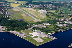
Kiel-Holtenau helicopter landing pad (Unterland)
| Heliport Kiel-Holtenau (Unterland) | |
|---|---|

|
|
| Characteristics | |
| ICAO code | ETMK |
| Coordinates | |
| Height above MSL | 4 m (13 ft ) |
| Transport links | |
| Distance from the city center | 7.5 km north of KIEL |
| Basic data | |
| opening | 1913 |
| operator | GNY (German Navy → German Navy ) |
| Start-and runway | |
| 04/22 | 120 m × 80 m asphalt |
The Kiel-Holtenau (Unterland) helicopter landing pad is located in the Holtenau district of Kiel below the Kiel airport, directly on the Kiel Fjord . In 1913 this airport in the "Unterland" was built using excavated earth from the Kiel Canal.
It was used by the German Armed Forces' Naval Aviation Squadron 5 until 2012 and has not been in operation since.
Web links
- Photo of work on the helipad
- Structural and usage concept for the area of Marinefliegergeschwader 5 in Kiel-Holtenau. City Planning Office Kiel, June 30, 2008, accessed on June 13, 2016 .
Individual evidence
- ^ Directory of military airfields and heliports. In: MILITARY AVIATION MANUAL GERMANY. October 21, 2010, archived from the original on July 19, 2011 ; accessed on June 13, 2016 .
- ↑ Last Navy helicopter flown out. kn-online.de, November 6, 2012, accessed on June 13, 2016 .