Baumholder Army Airfield
| Baumholder Army Airfield | |
|---|---|

|
|
| Characteristics | |
| ICAO code | ETEK, until 1995 EDEK |
| Coordinates | |
| Height above MSL | 442 m (1450 ft ) |
| Transport links | |
| Distance from the city center | 1.5 km northeast of Reichenbach , 4.7 km north of Baumholder |
| Street | 55774 Baumholder |
| train | Heimbach (Nahe) –Baumholder railway to Baumholder station |
| Local transport | Line 322 of the Rhein-Nahe local transport network to Baumholder, only on weekdays |
| Basic data | |
| opening | before 1945 |
| operator | US Army |
| Start-and runway | |
| 07/25 | 572 m × 16 m asphalt |
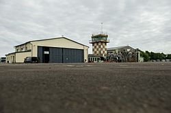
The Baumholder Army Airfield is a military airfield in the US Army in the NATO - military training area Baumholder near Baumholder in western Rhineland-Palatinate . It is located about 1.5 km from the center of Reichenbach and about 5 km north of Baumholder. The airfield has a 572 m long asphalt runway oriented 07/25. There are two hangars and a tower on the airfield site. The airfield is operated by the 1st Armored Division .
use
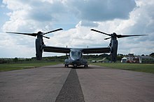
Currently (as of 2016) mainly Bell Boeing V-22s , various helicopters and small surveillance drones such as the RQ-11 “Raven” land at the airfield , which can take off vertically or require very little space to take off. Larger aircraft cannot land in Baumholder because of the comparatively short runway, but have to move to Ramstein .
Web links
- baumholder.army.mil ( Memento from February 28, 2015 in the Internet Archive ) Website of the US Army Garrison Baumholder
- airport-data.com - Photo of the airfield from 2006
- eddh.de - landing information with photo
Individual evidence
- ↑ a b c Airfields in Germany: Baumholder AAF . mil-airfields.de. Retrieved June 21, 2019.
- ↑ Baumholder Army Airfield, 1995 . usarmygermany.com. Retrieved October 27, 2011.
- ↑ Baumholder at usarmygermany.de
- ↑ Matt Millham: Despite upgrades, training, Baumholder's future still up in the air , Stars and Stripes, October 17, 2014
