Herekino Harbor
| Herekino Harbor | ||
| Geographical location | ||
|
|
||
| Coordinates | 35 ° 17 ′ S , 173 ° 11 ′ E | |
| Region ISO | NZ-NTL | |
| country | New Zealand | |
| region | Northland | |
| Sea access | Tasman Sea | |
| Data on the natural harbor | ||
| Port entrance | 160 m wide | |
| length | around 4.5 km | |
| width | max 0.74 km | |
| Coastline | around 14 km | |
| places | Herekino | |
| Tributaries | Herekino River and some streams (brooks) | |
| Photography of the natural harbor | ||
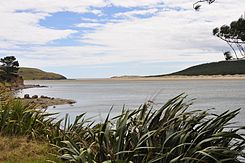
 Herekino Harbor , view of the Tasman Sea , towards the port entrance |
||
Herekino Harbor is a natural harbor in the Northland region ofthe North Island of New Zealand .
Origin of name
The name of the water is based on the area that the Māori chief Tohe passed on the way to visit the chief Taunaha , who lived in Owhata . He found an improperly tied bird's noose that would have caused unnecessary suffering to a potential victim. He named the area Herekino-a-Taunaha (the wrong knot of Taunaha ).
geography
The Herekino Harbor is located approximately 20 km south-southwest of Kaitaia and 17 km southeast of the Tauroa Point of Tauroa Peninsula on the west coast of Northland Peninsula . In its longest extension, the natural harbor measures around 4.5 km and at its widest point it is around 740 m. Its coastline extends for around 14 km and the 160 m wide port entrance gives access to the Tasman Sea . The largest inflow to the port is the Herekino River , which forms around 3 km upstream and north of the small settlement Herekino through the confluence of the Manukau Stream and the Uwhiroa Stream .
description
From the port entrance to the Herekino River, half of the northern bank of the natural harbor consists of a sandy beach, which can be up to 200 m wide at the port entrance and becomes narrower towards the inland. The estuary of the Herekino River and parts of the upper port are covered with mangrove trees and bushes, as is most of the southern branch. The small settlement Herekino has no direct access to the natural harbor.
See also
Individual evidence
- ↑ Parkes : The Visitors' Guide to the Far North . 1968, p. 14 .
- ↑ Topo250 maps . Land Information New Zealand , accessed November 11, 2017 .
- ↑ Coordinates and longitudes were partly made using Google Earth Pro version 7.3.0.3832 on November 11, 2017.
- ^ Herekino Harbor, Northland . NZ Topo Map , accessed November 11, 2017 .
