
Hergla
| Hergla |
|||
|---|---|---|---|
 |
|||
| administration | |||
| Country |
|
||
| Governorate | Sousse | ||
| Demographics | |||
| population | 6332 pop (2004) | ||
| Population density | 528 inhabitants / km² | ||
| geography | |||
| surface | 12 km² | ||
|
|||
| Coordinates | 36 ° 2 ′ N , 10 ° 30 ′ E | ||

Hergla ( Arabic هرقلة) is a small town in Tunisia , located on the Gulf of Hammamet on the Mediterranean coast . The city is about 90 kilometers south of Tunis and has around 6,500 inhabitants.
history
In antiquity , the then Roman settlement was called Horrea Caelia . It was a border town between the late Roman provinces of Byzacena and Zeugitana . In the Middle Ages the city was ruled by the Byzantines and the Order of Malta . Excavations can still be seen there today.
Buildings
The community is dominated by the mosque of Sidi Bou Mendil . The name comes from a local Mecca pilgrims return consisting of Mecca should be returned to a handkerchief. The cemetery is idyllically located on the slope facing the harbor.
economy
Compared to the neighboring cities of Hammamet or Port El-Kantaoui , Hergla is only used for tourism to a small extent. The port lives mainly from transport and repair services. In addition, fishing serves as an employer. Due to its location on a salt lake, there are many basket weavers in the village who make their goods from Halfagras and the like. a. drive away to tourists.
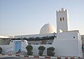
The Sidi Bou Mendil mosque
Church life
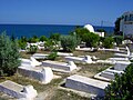
Hergla cemetery


Web links
Individual evidence
- ↑ a b Institut National de la Statistique - Tunisie: Census 2004 ( Memento of the original from September 24, 2015 in the Internet Archive ) Info: The archive link was inserted automatically and has not yet been checked. Please check the original and archive link according to the instructions and then remove this notice. . ( french )