Behind the Magni Church
| Behind the Magni Church Magnikirchhof
|
|
|---|---|
| Street in Braunschweig | |
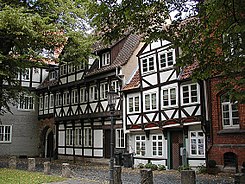
| V. l. To the right: Behind the Magni Church 3, 4, 5, 6 | |
| Basic data | |
| place | Braunschweig |
| District | Magniviertel |
| Connecting roads | Magnikirchstrasse |
| Places | Magnikirchplatz |
| Buildings | St. Magni , more see below |
| use | |
| User groups | Pedestrian traffic , bicycle traffic , car traffic (no through traffic) |
| Road design | paved |
Behind the Magnikirche is a small, paved street in the Magniviertel of Braunschweig . It used to be called Magnikirchhof and now leads from Magnikirchstrasse to Magnikirchplatz. The street covers the area of the Magnikirche in the north. A narrow path for pedestrians leads to the Herrendorftwete at its end .
history
The Magniviertel is part of the precincts of Altewiek and one of the oldest settlement areas of the city of Braunschweig. The consecration certificate of the Magni Church from 1031 is also the oldest documentary evidence of the name "Brunesguik", which about 400 years later became "Braunschweig". Two long-distance trade routes ran through the Altewiek , of which the northern one came through the Magnitor and ran past the Magnikirchhof on the Ackerhof .
During the Second World War , the Magni Church and the quarter of the same name were very badly damaged, especially by bomb attacks on April 23 and October 15, 1944. The church was restored from 1956 to 1964 in a significantly changed, simplified and partly modern form. The north side facing “Behind the Magni Church” is made of concrete with long windows. The modern stained glass shows the Israelites' march through the Red Sea.
The street “Hinter der Magnikirche” was expanded into a traditional island with the Magniviertel, with half-timbered houses being moved here to fill gaps in the bombs. The last building on the north side is the St. Magni Protestant day care center ( (map) ).
Listed buildings
|
Magni Church Location: (map) Erected: 1252 / 1956–1964 |
|
Behind the Magnikirche 1 Location: (map) Erected: 1645/1913 |
|
Behind the Magnikirche 4 - rectory of St. Ulrici Location: (map) Erected: (1514) / after 1954 |
|
Behind the Magnikirche 5 Location: (map) Erected: |
|
Behind the Magnikirche 6 Location: (map) Erected: 1885 |
|
Behind Magni Church 7 - rectory of St. Magni Location: (map) Erected: 1705 |
|
Behind the Magnikirche 6A - State Theater House 3 Location: (map) Erected: |
literature
- Jürgen Hodemacher : Braunschweig's streets - their names and their stories. Volume 1: Inner City. Cremlingen 1995, ISBN 3-92706-011-9 .
- Wolfgang Kimpflinger: Monument topography Federal Republic of Germany . Architectural monuments in Lower Saxony. Volume 1.1 .: City of Braunschweig. Part 1. Hameln 1993, ISBN 3-87585-252-4 .
- Heinrich Meier : The street names of the city of Braunschweig. In: Sources and research on Brunswick history. Volume 1, Wolfenbüttel 1904.
Web links
Individual evidence
- ↑ Wolfgang Kimpflinger: Monument topography Federal Republic of Germany. Architectural monuments in Lower Saxony. Volume 1.1 .: City of Braunschweig. Part 1, p. 138.
- ↑ BLIK : Magniviertel. (accessed on June 8, 2018)
- ↑ According to the inscription on the building.
Coordinates: 52 ° 15 ′ 45.4 " N , 10 ° 31 ′ 47.9" E


