Hinterbrühl (Munich)
Hinterbrühl is a place name in Munich .
location
The desert is in the Thalkirchen district south of the Maria Einsiedel district between the Isar high bank and the Isar-Werkkanal . The raft channel runs through the area . To the north of Hinterbrühl are the central area and the Munich Thalkirchen golf course, to the south a road leads to the Pullach Adolf-Wenz settlement .
history
In the 19th century Hinterbrühl was part of the then still independent municipality of Thalkirchen . The name was originally the name for an economy farm, from which the Gasthof Hinterbrühl later emerged. The part of the name Brühl indicates the location in the Isar floodplains. Gradually the name was also transferred to the area. As part of the construction of the raft canal and the central area in 1899 and the extension of the Isar works canal in 1906, the Hinterbrühler See was created in the corner between the two . The name Hinterbrühl was officially recognized as a toponym by the Ministry of the Interior with effect from January 1, 1907.
description
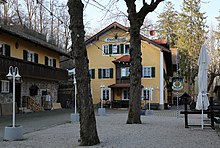
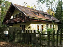
There are only a few buildings in Hinterbrühl: the Gasthof Hinterbrühl that emerged from the Ökonomiehof, the Hinterbrühl lock keeper's house built in 1899 in connection with the construction of the central area, as well as a boathouse and a small beer garden on the lake. Otherwise, Hinterbrühl is a park around the Hinterbrühler See and thus part of a chain of green areas on the Isar slope edge, which stretches almost continuously from Hinterbrühl over the Gierlinger Park and the Neuhofener Berg to below the Harras .
The Hinterbrühl area is part of the Isarauen landscape protection area ( LSG-00120.09 ).
Web links
Individual evidence
- ↑ a b Helmuth Stahleder : From Allach to Zamilapark . Buchendorfer Verlag, Munich 2001, ISBN 3-934036-46-5 , p. 57 .
- ^ A b Denis A. Chevalley, Timm Weski: State Capital Munich - Southwest (= Bavarian State Office for Monument Preservation [Hrsg.]: Monuments in Bavaria . Volume I.2 / 2 ). Karl M. Lipp Verlag, Munich 2004, ISBN 3-87490-584-5 , p. 300 .
Coordinates: 48 ° 5 '8.4 " N , 11 ° 32' 27.5" E


