
Hipfelhof

The Hipfelhof is a historic estate in the Frankenbach district of the city of Heilbronn in Baden-Württemberg .
history
Settlement history

Hipfelhof, west of Frankenbach, was first mentioned in 1229 when Pope Gregory IX. confirmed the ownership of the Bebenhausen monastery in Hüppelbure . Other historical names are Hipfelbeuren , Hüpfelhof and Hupphilbura . The imperial bailiff Wilhelm von Wimpfen donated his property at the Hipfelhof to the hospital master of the Order of the Holy Spirit in Wimpfen in 1250 . To the southwest of today's Hofgut there are further traces of settlement, so that the settlement of the Hipfelhof was once more extensive and extensive. The name Hipfelbeuren also indicates a village settlement, whose ownership structure, according to the documents that have been received, was very fragmented as early as the 13th century.
There was already a pilgrimage chapel near the village in the Middle Ages, for which a pastor was named for the first time in 1475. In the 16th century, the settlement came into the possession of the Stephansfeld Abbey , which belongs to the diocese of Strasbourg and to which the administration of the Wimpfen hospital had gone. Around 1550 the imperial city of Heilbronn lent the convent in Stephansfeld the majority of what was later up to 17,700 guilders, for which the city received the Hipfelhof as well as the church fee and the parish loan in Flein as pledge. The Württemberg house , the hospital in Wimpfen and the Counts of Hanau sought the property, which was sold to the city of Heilbronn in 1601 by a master of the convent. In the documents for this sale only one farm is mentioned, so that at that time a large part of the village structure of the settlement should already have been lost.
The sale to the imperial city of Heilbronn was controversial, so that several complaints were received by the Reichshofrat and the matter remained in limbo. In 1619 the city of Heilbronn took possession of the court, whereupon Stephansfeld and Wimpfen again filed a lawsuit. In 1628 there was a settlement between the convent master and the order with the imperial commission decision that the city of Heilbronn had to return the court to the order and that the order would pay its debts.
In 1695 the farm consisted of the farmhouse, the chapel and a barn and came into the possession of the hospital in Memmingen. The buildings were occasionally renovated and expanded over the years: the chapel was renewed in 1715/18, the mill and rectory were built in the late 18th century.
In 1803 the property fell to Bavaria, but shortly afterwards it was donated to the Bavarian Foreign Minister Maximilian von Montgelas . In 1812 the von Cotta publishers and barons acquired the property, which was owned by the family until 1959. Due to the Bavarian affiliation, the land belonging to the Hofgut had its own mark, but then came under administrative affiliation to Frankenbach . The chapel north of today's Hofgut was destroyed in the Second World War.
The Hofgut still exists today, one of the buildings serves as Südzucker's administrative office .
Hipfelhof project
From 1949, the Heilbronn District Office had plans to build a large housing estate for a total of 4,000 to 5,000 people, in which mainly commuters from the industrial cities of Heilbronn and Neckarsulm find a new home and from which they can quickly reach the industrial areas in Heilbronn and Neckarsulm by bike should. After examining several settlement options in the greater Heilbronn area, the area belonging to the Hipfelhof appeared to be the most suitable. The Wuerttemberg-Baden Ministry of Agriculture and the Ministry of the Interior signaled their consent to financial support in the context of social housing , as the Heilbronn district could not finance the project from funds under the law for the procurement of settlement land and the land reform . While in a survey in September 1949 almost 1000 families from the Heilbronn area expressed interest in resettlement, the acquisition of the land proved difficult. At first it was assumed that the land reform tax of the Hipfelhof owner, Baron Cotta von Cottendorf, would amount to 120 hectares. However, since the Ministry of Agriculture had declared the Hipfelhof to be a special enterprise in the cultivation of seeds, the land tax was reduced to 20 hectares, whereas the Landratsamt at the Landessiedlungsamt had already requested almost 40 hectares in May 1949 and 80 hectares in October 1949 for the construction of settlements. After Freiherr Cotta von Cottendorf did not agree to any voluntary increase in his land tax, Minister of Agriculture Heinrich Stooß ordered him in February 1950 to pay a land tax of 45 hectares, which, after tough negotiations, was implemented by an expropriation order in August 1950. For the planned settlement, the district would only have to purchase 25 to 35 hectares from private sources. In February 1951, Freiherr Cotta von Cottendorf brought an action to challenge the expropriation. Although the expropriation was found to be legal, the administrative court in Stuttgart forbade the use of the disputed land for purposes of social housing. The district office then worked out a plan to settle the area with full, small and part-time settlements, which, however, was also rejected by the Agriculture Minister in December 1951. The Hipfelhof lands were not settled. The planned large commuter settlement was instead built in Amorbach .
building

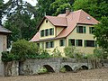
In the north-west of the complex is the three-storey Cotta'sche Villa (No. 6) from 1855, which was expanded in 1865 and 1875 and is surrounded by park-like grounds.
In the northeast of the complex is the former rectory (No. 10, also called Speisemeisterei or Jägerhaus), which was built in 1791 and renovated in 1855, as well as the mill (No. 8) from 1784 with a two-storey storage extension. The north facade of the mill has an ornate former portal as well as figural decorations on the lintels. An old aqueduct leads from the north to the mill, which shows an inscription stone dated 1843.
In the south of the complex there is a courtyard with residential and farm buildings, which are arranged at right angles around a cottage garden. The larger residential building (No. 1, Südzucker administration) was built as a two-story half-timbered building around 1700, the smaller residential building (No. 2) was created by converting a stable building from 1830. The farm buildings (No. 3, 4 and 7) were built after a Brand built around 1870, partly on older foundations.
Aqueduct north of the mill, in the background the rectory

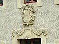
Wappenstein on the aqueduct
Mill, former portal
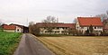
Courtyard with buildings No. 1 (right) and No. 2 (middle)


Others


In the Hipfelhofwald, which lies in the direction of Kirchhausen - Annalinde, the grave of Baron Carl von Cotta is in the middle of the forest. You can still see the large tombstone and the remains of the border. Apparently the grave was laid out very modestly from the start. The grave site is on a slight slope from which, with a clear view, the Hipfelhof's lands could be seen. At the moment the grave is surrounded by bushes and trees, the access through the undergrowth is apparently cut open every now and then.
Individual evidence
literature
- Peter Wanner: Devastation in Heilbronn and the surrounding area. Preliminary report on a research desideratum. In: heilbronnica 2. Contributions to the history of the city , Heilbronn 2003 (sources and research on the history of the city of Heilbronn 15), pp. 9–50.
- Monika Kolb: refugee, new citizen, lowlander. Admission and integration of the displaced in the Heilbronn district between 1945 and 1953 . Heilbronn district, Heilbronn 1990, ISBN 3-9801562-3-0 ( Series of publications of the Heilbronn district . Volume 3)
- Julius Fekete , Simon Haag, Adelheid Hanke, Daniela Naumann: Heilbronn district . (= Monument topography Federal Republic of Germany , cultural monuments in Baden-Württemberg, Volume I.5.). Theiss, Stuttgart 2007, ISBN 978-3-8062-1988-3 , pp. 185-187 .
Web links
Coordinates: 49 ° 9 ′ 32 ″ N , 9 ° 8 ′ 48 ″ E