Hirsholmene
| Hirsholmene | ||
|---|---|---|
| Hirsholm | ||
| Waters | Kattegat | |
| Geographical location | 57 ° 29 ′ N , 10 ° 37 ′ E | |
|
|
||
| Number of islands | 10 | |
| Main island | Hirsholm | |
| Total land area | 0.47 km² | |
| Residents | 1 (January 1, 2020) | |
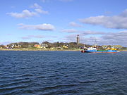
Hirsholmene is the northernmost Danish group of islands in the Kattegat . Most of the islands in the group are elevations of a sandbank about 7 km northeast of Frederikshavn . The total area of the islands and some small sands is 47 hectares . With the exception of Hirsholm (four residents; January 1, 2009), the islands are uninhabited. Since 1934, almost all of the islands and the surrounding marine area with an area of 2400 hectares have been protected.
history
Finds of pottery shards show that Hirsholm and Græsholm were already inhabited in prehistoric times. Three large lumps of amber (reg.no. A 22 517 - A 22 519) were found under boulders 100 meters from the bank. Hirsholm was first mentioned in a document in 1231 in the Liber Census Daniæ at the time of King Waldemar II.
Islands
![]() Map with all coordinates of the section Islands : OSM
Map with all coordinates of the section Islands : OSM
| island | Coordinates | Area ha |
Remarks |
|---|---|---|---|
| Hirsholm | 57 ° 29 '08 " N , 010 ° 37' 28" E | 15.0 | Inhabited nature reserve |
| Græsholm | 57 ° 29 ′ 34 " N , 010 ° 36 ′ 30" E | 21.5 | Nature reserve |
| Tyvholm | 57 ° 29 '55.1 " N , 010 ° 36' 13.5" E | 0.41 | Nature reserve |
| Lilleholm | 57 ° 29 '31.0 " N , 010 ° 36' 10.1" E | 0.18 | Nature reserve |
| Møgholm | 57 ° 29 '35.5 " N , 010 ° 36' 00.9" O | 0.61 | Nature reserve |
| Pikkerholm | 57 ° 29 '47.9 " N , 010 ° 36" 03.1 " E | 2.2 | Nature reserve |
| Kovsholm | 57 ° 29 '48.1 " N , 010 ° 35' 51.4" E | 1.2 | Nature reserve |
| Kølpen | 57 ° 28 '23.6 " N , 010 ° 36' 15.8" E | 1.2 | Nature reserve |
| Deget | 57 ° 27 '03 " N , 010 ° 34' 48" E | 4.8 | Nature reserve |
| Hjellen | 57 ° 27 '03.8 " N , 010 ° 33' 53.0" E | 0.08 | no nature reserve |
| Hirsholmene | 57 ° 29 '07.6 " N , 010 ° 37' 28.4" E | 47 |
The two southernmost islands Deget and Hjellen are relatively remote from the rest of the Hirsholmene in the immediate vicinity of the coast.
Hirsholm
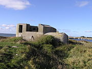
In 1641 the church was built and the first school was set up. Around 1800 about 100 people lived on Hirsholm. The first beacon on the island was put into operation in 1838. Until 1853 the island belonged to the king, after which several nobles changed as landlords. The port was built in 1860 and 1861, and in 1870 the island reached its densest settlement with 225 inhabitants. In 1884 the Ministry of the Navy took over the administration of the archipelago. Bunkers from the Second World War still exist on Deget and Hirsholm . In 1970 the school was closed. In the summer months the church is still used for church services. It belongs to the parish community ( Danish : Sogn ) Frederikshavn Sogn , which until 1970 belonged to Harde Horns Herred in what was then Hjørring Amt , from 1970 to Frederikshavn Kommune in what was then Nordjyllands Amt , which became part of the municipal reform on January 1, 2007 in the "new “ Frederikshavn Municipality has risen up in the Nordjylland region.
In 2009 only four people lived permanently on Hirsholm. Most of the buildings are used as holiday homes.
Economy and Transport
From the 16th to the 18th century, fishing was the main source of income. Another line of business was pilotage, but this became unprofitable in 1916 with the opening of the Kaiser Wilhelm Canal . Smuggling and collecting flotsam also served as a means of subsistence. From 1760 to 1909 there was an inn on the island. Today most of the houses are used as holiday accommodation. The post boat connection with Frederikshavn , established in 1872 , currently operates 3 times a week. Dogs and cats are not allowed on the island.
beacon
The first lighthouse was built in 1883 in the form of a residential house with an attached lamp house and a fire height of nine meters above sea level . The current 27 m high beacon was built in 1886 on Ørnehøj, the highest point on Hirsholme. The granite on the island served as building material. The Hirsholm beacon (International No .: C0020) has a fire height of 30 meters. When the port was later built, a pier light (International No .: C0024) was also set up.
Græsholm
Græsholm is the largest island in the group and is separated from Hirsholm by the 150 m wide and 30 cm deep Bredsund.
Deget
The southernmost island in the nature reserve can be entered. It is located about a kilometer northeast of the port of Frederikshavn.
Landscape and nature

The Hirsholmenen are part of the wetland project under the Ramsar Convention .
Web links
Individual evidence
- ↑ The Store Danske Encyklopædi , entry: Hirsholmene , accessed on April 30, 2012
- ↑ www.statistikbanken.dk → Befolkning og valg → Folketal → Table BEF4 (Folketal pr. January 1, fordelt på øer) , accessed on October 5, 2009
- ↑ M. Rech: Studies on Depot Finds ... 1979 p. 128
- ↑ https://rsis.ramsar.org/ris/147


