Hoanib
| Hoanib | ||
|
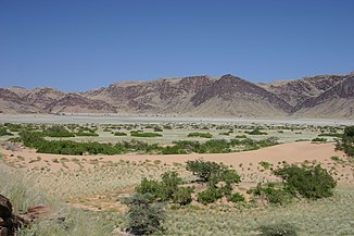
Flood plain of the Hoanib east of Sesfontein |
||
| Data | ||
| location | Namibia | |
| River system | Hoanib | |
| muzzle | in the Atlantic Coordinates: 19 ° 28 ′ 22 ″ S , 12 ° 45 ′ 22 ″ E 19 ° 28 ′ 22 ″ S , 12 ° 45 ′ 22 ″ E
|
|
| length | 270 km | |
| Catchment area | 15,760.517 km² | |
The Hoanib is one of the 12 ephemeral dry rivers in western Namibia where it forms the border between northern Damaraland and the Kaokoveld . Its length is 270 km. With the sparse population density, the oasis character of the river valley and the relatively high game population, the Honaib, together with the Hoarusib, represents one of the last real wilderness areas in Namibia. The river valley of the Hoanib is one of the last settlement areas for desert elephants and has strong wind and water erosion weathered stone deposits (up to 10 m high). Tributaries of the Hoanib are Ombonde , Ganamub , Mudorib and Tsuxab .
Hydrology
The catchment area of the Hoanib covers 15,760.517 km² and extends from the west coast to Ojiovasando and the black peaks inland, it also includes the spring-rich region around Sesfontein , Warmquelle and the Khowarib Gorge. The highest point of the catchment area is 1,800 m. Precipitation in the catchment area is sporadic and varies from 0 mm / a in the west to 325 mm in the northeast of the catchment area. The area share with less than 100 mm / a is 71%, only on 12% of the catchment area is the annual precipitation over 300 mm. The Hoanib only comes off every few years during heavy rainfall in the hinterland of the catchment area, but then the tide can be several meters high and last for several days. Not always, but more frequently in recent years, the water also reaches the confluence with the Atlantic. A large part of the water seeps away and contributes to a larger body of groundwater lying just below the surface , from which groundwater escapes at some points in the river bed even in dry years. The salt efflorescence that often forms in the presence of groundwater is used by numerous antelopes as salt licks. In dry times, the desert elephants living in the Hoanib dig holes meter- deep in order to access the groundwater near the surface.
Vegetation and fauna
The vegetation of the catchment area mainly comprises Mopane savannah (87%) and northern Namib with 13%. In the area of the gallery forests there are in part larger populations of ana trees ( Faidherbia albida ), leadwood ( Combretum imberbe ), mopane ( Colophospermum mopane ), camel thorn ( Acacia erioloba ) as well as Salvadora and Euclea . Especially after the agreement and in the area of the wetlands there are larger, often meter high stocks of sour grasses and reeds .
With its gallery forests and the larger wetlands in the Khowarib Gorge, in a flood plain east of Sesfontein and on the lower reaches and estuary, the Hoanib represents a linear oasis in the otherwise desert-like environment and thus provides the basis for a rich fauna. In addition to larger populations of numerous antelope species, there are also a larger number of desert elephants (around 35 individuals), black rhinos , giraffes, but also several prides of lions and smaller predators in the lower reaches of the Hoanib .
Use and settlement
91% of the catchment area is located as communal land in tribal administration, the private land ownership with 3% is distributed over 12 farms. 6% of the catchment area is in the area of the Skeleton Coast Park. The population is estimated at around 9200. Settlement focuses Sesfontein and Warmquelle and Otjivasando . The land use is predominantly pastoral . Individual and adventure tourism is also increasingly playing a role in the region. To the west of Sesfontein, the Hoanib Valley is part of the Desert Adventure Safaris concession area. The increasing tourism, but also the grazing pressure of the local population and the desires in the mining industry are increasingly threatening the unique ecosystem of the Hoanib Valley.
literature
- Mary Seely, Kathryn M. Jacobson, Peter J. Jacobson: Ephemeral Rivers and Their Catchments - Sustaining People and Development in Western Namibia . Desert Research Foundation of Namibia, 1995, ISBN 978-99916-709-4-2
- Klaus Hüser, Helga Besler, Wolf Dieter Blümel, Klaus Heine, Hartmut Leser, Uwe Rust : Namibia - A Landscape Studies in Pictures . Klaus Hess, Göttingen / Windhoek 2001, ISBN 978-3-933117-14-4
- Julian Thomas Fennessy: The ecology of desert-dwelling giraffe (Giraffa camelopardalis angolensis) in northwestern Namibia . Diss., Sydney 2004
Individual evidence
- ↑ Mapping the Major Cathments of Namibia. Ben Ben J. Strohbach, National Botanical Research Institute, pp. 5-6.
