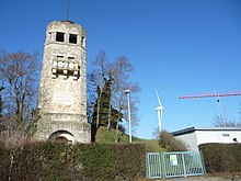
Wintersheim elevated tank
The elevated reservoir Wintersheim was built in 1906 in Art Nouveau style on the so-called 231 meter high Scheelebell between the villages of Wintersheim and Eimsheim , as main reservoir II - water supply for the Rhine-Selz area with a capacity of 1,000 cubic meters .
meaning
The elevated tank is considered to be the heart of the drinking water supply in Rheinhessen . From here, the water flows to over 60 localities, including bulk buyers. Only a few places are connected via a pressure line or with pumps, most of them are regulated via the normal gradient.
layout
In addition to the Guntersblum pumping station , today's Wasserversorgung Rheinhessen GmbH (WVR), the main elevated tank was designed very elaborately. The facade is decorated with sandstone blocks from the former Flonheim quarries . The architect Wilhelm Lenz , under the head of building officer Bruno von Boehmer , had an 18-meter-high observation tower built above the container , from the balcony and platform of which one has a wide view over the Rhine-Hessian hill country and the Rhine plain . As part of the Wintersheim Wine Hiking Day on the first Sunday in September, the WVR opens the site and you have the opportunity to visit the newest of the three existing water tanks. It is not possible to visit the elevated tank tower.
In addition to the over a hundred year old elevated tank, there are other sober main elevated tanks and pumping stations of the "Water Supply Association Rhein-Selz -gebiet" and the WVR from 1973 and 1996.
history
On October 14, 1907, the water supply system for the Rhine-Selz area was officially opened. The Hessian Interior Minister Ernst Albrecht Braun was given the golden key to open the plant.
See also
Individual evidence
- ^ Werner Lang: How the Wintersheim water tower was inaugurated ; in: Heimatbuch Landkreis Mainz; Printed by Wilhelm Traumüller, Oppenheim am Rhein 1967; P. 178
Web links
- The Wintersheim elevated tank
- Wintersheimer water tower
- Information ( memento of September 28, 2007 in the Internet Archive ) of the Guntersblum Association
-
Rheinhessen water supply
- Bike path to the water house
- WVR - Tower appears in a new light ( Memento from September 28, 2007 in the Internet Archive ), accessed in the Internet archive on January 27, 2016
- Wintersheim Wine Hiking Day
Coordinates: 49 ° 47 ′ 4 " N , 8 ° 16 ′ 57" E


