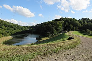
Flood retention basin Oberstetten
| Flood retention basin Oberstetten | |||||||
|---|---|---|---|---|---|---|---|
| Flood retention basin Oberstetten | |||||||
|
|||||||
|
|
|||||||
| Coordinates | 49 ° 22 '7 " N , 9 ° 57' 35" E | ||||||
| Data on the structure | |||||||
| Lock type: | Zone dam | ||||||
| Construction time: | 1984 | ||||||
| Height of the barrier structure : | 22.4 m | ||||||
| Height of the structure crown: | 385 m above sea level NN | ||||||
| Building volume: | 155 000 m³ | ||||||
| Crown length: | 190 m | ||||||
| Crown width: | 6 m | ||||||
| Operator: | Water Association Kaiserstraße | ||||||
| Data on the reservoir | |||||||
| Altitude (at congestion destination ) | 370 m above sea level NN / 382.6 m above sea level NN | ||||||
| Water surface | 1.35 ha / 9.80 ha | ||||||
| Storage space | 63,000 / 723,000 m³ | ||||||
| Total storage space : | 813,000 m³ | ||||||
| Catchment area | 16 km² | ||||||
The Oberstetten flood retention basin (also: Vorbach retention basin ) was built in 1984 above Oberstetten , a district of Niederstetten , on the Vorbach to protect Oberstetten from flooding.
The basin has a small permanent reservoir with an area of 1.35 ha and a volume of 63,000 m³, which can grow to 9.8 ha and 813,000 m³ of total storage space during floods. The operator is the “Kaiserstraße” water association in Niederstetten.
The permanent destination is at 370 m above sea level. NN , the overflow at 382.6 m above sea level. NN . During a 200-year flood, the water level can rise to 383.35 m above sea level. Rise above sea level . The hundred-year design flood is 17.60 m³ / s.
The dam is around 23 m high, 190 m long, 6 m wide at the top and is not far from Landstrasse 1001. It is a zone dam with a construction volume of 155,000 m³. The construction costs amounted to the equivalent of 2.23 million euros.

