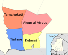
Hodh El Gharbi
Hodh El Gharbi ("Western Basin", Arabic ولاية الحوض الغربي, DMG Wilāyat al-Ḥauḍ al-Ġarbī ) is the eighth of the fifteen administrative regions of the African state of Mauritania . In 2017 the population was estimated at 313,700.
administration
It is centrally located to the south and is surrounded by the Mauritanian regions Tagant in the north, Hodh Ech Chargui in the east and Assaba in the west and borders Mali in the south .
The capital is Ayoûn el-Atroûs . Hodh El Gharbi is divided into the four departments Tamcheket , Tintane , Aioun el Atrouss and Kobenni .
geography
The drainless Aoukar Depression , which includes parts of the three administrative regions in the southeast of Mauretanion, extends in the north to Tichit on the edge of the Tagant Plateau. In west-east direction it extends from Kiffa in the Assaba region to Néma in the Hodh Ech Chargui region. The plain was covered by a lake from around 1,700 BC to around 500 BC, which slowly dried up and silted up. The settlements on the edge of the lake were abandoned by their inhabitants.
Individual evidence
- ↑ Mauritania: Regions, Cities & Urban Places - Population Statistics in Maps and Tables. Retrieved May 15, 2018 .
Coordinates: 16 ° 33 ′ N , 9 ° 45 ′ W


