Hohtürli
| Hohtürli | |||
|---|---|---|---|
| Compass direction | West side | East Side | |
| Pass height | 2778 m above sea level M. | ||
| region | Kandertal | Kiental | |
| Watershed | Oeschinensee , Kander | Gamchibach , Gornerwasser , Chiene | |
| Valley locations | Kandersteg | Griesalp | |
| expansion | Mountain path | ||
| Mountains | Bernese Alps | ||
| map | |||
|
|
|||
| Coordinates | 625 447 / 151119 | ||
The Hohtürli is a 2778 m high Swiss mountain crossing in the Bernese Alps . It forms the connection from Kandersteg to the Kiental .
location
The Hohtürli forms an incision between the Blüemlisalp massif in the south and the Dündenhorn massif (with the Bundstock and Schwarzhorn peaks in the direction of Hohtürli) in the north. A natural rock gate that collapsed in the early 20th century gave the crossing its name.
The cut lies on the border between the Bernese Pre-Alps and the actual Bernese Alps .
Hiking routes
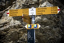
The path over the Hohtürli is a popular hiking route. From Kandersteg the top of the pass can be reached in approx. 5 hours; With the Oeschinensee (accessible via gondola lift) as the starting point, the hiking time is shortened by around an hour. The ascent from Griesalp in the Kiental takes around 4½ hours.
The Blüemlisalphütte of the SAC , located at the top of the pass, offers food and accommodation. On the Kiental side, the Gspaltenhornhütte can be reached via a path at the tongue of the Gamchi glacier , or the tour can be continued via Sefinenfurgge into the Sefinental / Lauterbrunnen valley .
The tour is part of the Hinteren Gasse , which crosses the Bernese Oberland, and the Via Alpina , a long-distance hiking trail through the entire Alpine arc.
literature
- Martin Gerber: Club Leader Bernese Pre-Alps. Verlag des SAC, 1997, p. 268.


