Hollerbach (Morre)
| Hollerbach | ||
|
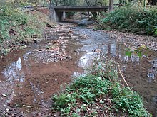
The Hollerbach just before its mouth |
||
| Data | ||
| Water code | DE : 2472411 | |
| location | Neckar-Odenwald district (Baden-Württemberg) | |
| River system | Rhine | |
| Drain over | Morre → Billbach → Mud → Main → Rhine → North Sea | |
| source | in Oberneudorf 49 ° 30 ′ 1 ″ N , 9 ° 15 ′ 55 ″ E |
|
| Source height | 405 m above sea level NN | |
| muzzle | at Buchen in die Morre coordinates: 49 ° 31 ′ 45 ″ N , 9 ° 18 ′ 33 ″ E 49 ° 31 ′ 45 ″ N , 9 ° 18 ′ 33 ″ E |
|
| Mouth height | 300 m above sea level NN | |
| Height difference | 105 m | |
| Bottom slope | 21 ‰ | |
| length | 5 km | |
| Catchment area | 11.3 km² | |
The Hollerbach is a left tributary of the Morre in the Odenwald in Baden-Württemberg .
course
The Hollerbach (from elder ) rises in Oberneudorf . It flows in a north-easterly direction through the village of the same name Hollerbach and feeds the dammed Hollersee . At Buchen it flows into the Morre near the Hainstadter Mühle .
Protected areas
The Hollerbach valley between Hollerbach and Buchen was designated as a landscape protection area with a size of 43.7 hectares by ordinance of the former Buchen district office of 16 May 1957 under the name Hollerbachtal . It has the protected area number 2.25.021 and is part of the FFH area "Odenwaldtäler Buchen-Walldürn" . The lower reaches of the Hollerbach is already part of the directly adjoining LSG Morretal (No. 2.25.014) between Buchen and Hettigenbeuern .
additional
Not far from the confluence with the Morre, at what is now the Buchen forest swimming pool, a cutting mill was operated in the 19th century .
See also
Web links
Individual evidence
- ↑ a b c Google Earth
- ↑ Discover regional studies online, Hollerbach. LEO-BW, accessed November 4, 2017 .
- ↑ Plan of the community forests of Buchen (1840). Baden-Württemberg State Archive, General State Archive Karlsruhe, accessed on November 6, 2017 .

