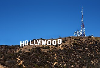
Hollywood Hills


The Hollywood Hills are a chain of hills and the residential area named after them in the Hollywood district above the city of Los Angeles in the US state of California . They are the easternmost part of the Santa Monica Mountains , adjacent to the west is Beverly Crest .
The boundaries of the Hollywood Hills borough within the legally defined borough of Hollywood, like all boroughs of Los Angeles, are unofficial in that there are no boundaries set by the city government. The Neighborhood Councils introduced in 1999 do not cover the entire city area.
The boundaries of the Hollywood Hills district in the north are the ridge of the Santa Monica Mountains, which separates the Los Angeles Basin from the San Fernando Valley . To the northwest, Mulholland Drive runs largely on or near the ridge. In the west, various streets in the hills are considered to be the boundary to the Beverly Crests, from east to west Laurel Canyon Boulevard , Sunset Plaza Drive , Lorna Vista Drive or the Beverly Hills exclave on Franklin Reservoir beyond Coldwater Canyon Drive . In the south, the Hollywood Hills are demarcated from the neighborhoods with the street grid typical of Los Angeles, the boundary line then runs from west to east on Sunset Boulevard , Hollywood Boulevard and Franklin Avenue . In the east, Universal Studios Hollywood and Griffith Park serve as the northern boundary; in the southeast, the district extends to Fern Dell Drive . The Los Angeles Times divides the Hollywood Hills into an east and a west part for internal purposes and draws the border on Laurel Canyon Drive . The district is accessed and divided at the same time by US Highway 101 via the Cahuenga Pass , which is called the Hollywood Freeway here .
The villa district and its partly spectacular buildings are the setting for countless films and books. The famous Mulholland Drive, which opens up the summit area in the western part of the district. The area has a proportion of green that is far above average for the greater Los Angeles area. The Santa Monica Mountains National Recreation Area in the western part contributes significantly to this. The eastern part is bordered by the largest urban park, Griffith Park. In the east part of the hill there is also the famous Hollywood Sign . In between is the Hollywood Reservoir , which was created in 1924 to supply the city with drinking water and is now a local recreation area. In the south of the area at the foot of the hills is the Hollywood Bowl , an open-air stage where music and other events take place.
In the 2011 song of the same name, Hollywood Hills by the Sunrise Avenue group , the villa district is sung about:
"Cause this is the end of the rainbow
Where no one can be too sad"
The text refers to the originally Celtic legend of the gold pot at the end of a rainbow and depicts the quarter as a place of wealth and happiness.
Individual evidence
- ↑ LA neighborhoods, you're on the map , Los Angeles Times, February 19, 2009
- ↑ The boundary description is largely based on: zipmap.net: Hollywood Hills with an overlay of Zip Codes
- ↑ Mapping LA , Los Angeles Times (PDF; 995 kB)
- ^ Los Angeles Department of Water and Power: Mulholland Dam & Hollywood Reservoir
Coordinates: 34 ° 6 ′ 56.4 " N , 118 ° 20 ′ 47.3" W.