
Holzbach (Elbbach, Hadamar)
| Holzbach | ||
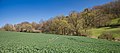
 Middle course of the Holzbach, taken north of Hadamar with a view in the direction of the river to the west |
||
| Data | ||
| Water code | DE : 2587676 | |
| location |
Giessen-Koblenz Lahntal
|
|
| River system | Rhine | |
| Drain over | Elbbach → Lahn → Rhine → North Sea | |
| source | north of Steinbach 50 ° 28 ′ 46 ″ N , 8 ° 6 ′ 5 ″ E |
|
| Source height | approx. 274 m above sea level NHN | |
| muzzle | in Hadamar in the Elbbach Coordinates: 50 ° 27 '11 " N , 8 ° 2' 46" E 50 ° 27 '11 " N , 8 ° 2' 46" E |
|
| Mouth height | approx. 137 m above sea level NHN | |
| Height difference | approx. 137 m | |
| Bottom slope | approx. 22 ‰ | |
| length | 6.1 km | |
| Catchment area | 7.297 km² | |
The Holzbach is a six kilometer long orographically left and eastern tributary of the Elbbach in Hadamar in central Hesse .
geography
course
The Holzbach rises about 500 meters north of Steinbach at an altitude of 274 m above sea level. NHN . First flowing in a southerly direction, the stream flows through the village of Steinbach. Then it turns its course to the west-southwest. After a river stretch of 6.1 km, the Holzbach flows out at 137 m above sea level. NHN on the left into the Elbbach . A mean bed gradient of 22.5 ‰ is calculated from the height difference of 137 meters. It drains its 7.297 km² catchment area via Elbbach, Lahn and Rhine to the North Sea.
The stream usually dries out over long periods of time. Initially running without a noticeable incision in the terrain, after around 3.5 kilometers northwest of Oberweyer, a separate brook valley begins to develop, which in the further course becomes an ever stronger incision in the terrain.

Upper course, taken north of Oberweyer with a view towards the northeast
Lower course of the Holzbach, taken north of Hadamar with a view to the east

The Holzbach shortly before its confluence with the Elbbach, taken from the Hammerweg in Hadamar with a view to the west


Elbbach river system
nature
The stream is accompanied by a narrow strip of softwood floodplain. In the upper reaches, this is limited to the immediate watercourse or is missing in sections. There, agriculturally used grassland and occasionally arable land extend right up to the stream. The floodplain belt widens in the lower reaches, especially in the more deeply incised areas. Larger stands of hedge land and smaller forests are also connected there.
Individual evidence
- ↑ a b Topographic map 1: 25,000
- ↑ a b Water map service of the Hessian Ministry for the Environment, Climate Protection, Agriculture and Consumer Protection ( information ) (query on November 22, 2010)