Howe sound
| Howe sound | |
|---|---|
|
Howe Sound by Stawamus Chief |
|
| Waters | Strait of Georgia |
| Land mass | North America |
| Geographical location | 49 ° 25 ′ N , 123 ° 24 ′ W |
| length | 42 km |
| Greatest water depth | 285 m |
| Islands | Bowen Island, Gambier Island |
| Tributaries | Squamish River |
|
Howe Sound from Cypress Mountain |
|
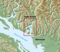
The Howe Sound is a bay on the Strait of Georgia to the northwest of Vancouver . Its entrance is between West Vancouver , in the Greater Vancouver Regional District and Langdale , in the Sunshine Coast Regional District . The bay extends about 26 miles inland before ending at Squamish .
geography
The Sea to Sky Highway runs along the south bank of Howe Sound and connects different communities. The larger communities are first at the entrance of the bay West Vancouver, in the bay then next Lions Bay and then Britannia Beach and Squamish end eventually. The northern bank is largely only very sparsely populated, in larger communities there is only Langdale at the entrance to the bay.
Islands in Howe Sound
The following islands are in Howe Sound:
There are also some small and tiny islands, such as the Pasley Group, Christie Islet, Pam Rocks or Woolridge Island. These small and tiny islands are partly privately owned or they are Indian reservations.
history
The story of Howe Sound begins with the appearance of the First Nation from the Squamish and Shishalh tribe . The two tribes belonging to the Coastal Salish family have settled and hunted in this area for centuries. With the Spanish exploration of the American west coast, this bay was first mapped as Boca del Carmelo in 1791. During the subsequent English exploration by Captain George Vancouver in 1794, it was given its current name after the Admiral of the British Royal Navy Earl Howe . Just like the Howe Sound itself, most of the islands in the sound are named after those involved in the sea battle on the Glorious First of June .
economy
The Howe Sound area flourished with the discovery of copper in the Britannia Creek area in 1888. For decades, the copper mines were the economic base in the Howe Sound area. However, major mining operations did not begin until the years after 1905. They were then to expand to the largest copper mine in the British Empire by 1929 . After the Second World War, production began to decline and in 1974 the mine was closed. On November 20, 1987, the former mine, known as Britannia Mines Concentrator , was declared a National Historic Site of Canada by the Canadian government . Today the focus of the economy is on the timber industry and tourism.
Web links
- Howe sound . In: BC Geographical Names (English)
- Site of the Canadian Ministry of Fisheries and Oceans Canada , English
- Info page about the Howe Sound, English
Individual evidence
- ^ Andrew Scott: The Encyclopedia of Raincoast Place Names: A Complete Reference to Coastal British Columbia . Harbor Publishing, Madeira Park, BC October 2009, p. 273-274 (English).
- ^ "Britannia Mines". Encyclopedia of British Columbia . Harbor Publishing. 2000
- ^ Britannia Mines Concentrator National Historic Site of Canada. In: Canadian Register of Historic Places. Retrieved July 9, 2020 .


