Hrazený
| Hrazený / Pirschken | ||
|---|---|---|
|
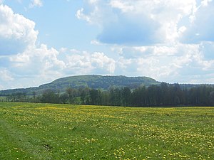
View to the Hrazený (Pirschken) |
||
| height | 610 m above sea level NHN | |
| location | Czech Republic | |
| Coordinates | 50 ° 58 '35 " N , 14 ° 25' 11" E | |
|
|
||
| rock | basalt | |
| particularities | Former mining houses | |
Hrazený (German Pirschken or Pirsken ) is at 609.7 m the highest mountain in the Bohemian Netherlands (Schluckenauer Winkel) in the Czech Republic . It is partially located in the present-day area of the city of Schluckenau and the neighboring Groß Schönau . The river Sebnitz and the Wölmsdorfer Bach flowing to Saxony originate in a wide valley between the Hrazený and the 593 m high Plešný (Plissenberg), two kilometers northwest of the village Brtníky (Zeidler).
History
On the north-eastern slope of the basalt Pirschken, the Schluckenau department of the mountain association founded in 1886 for northernmost Bohemia built the Pirs (ch) kenbaude . The inauguration of the mine took place on May 1, 1909 when the company was off . The corresponding property, which belonged to the neighboring Kaiserswalde, was owned by the Schluckenau department from the lawyer Dr. Hasenöhrl had previously been given as a gift, which is why the hut had the location list number 325 of Kaiserswalde . In 1937 the property and the chalet were assigned to Kunnersdorf. For this reason, a driveway for motor vehicles was created from there to the Bergbaude, which branched off from the Schluckenau-Zeidler district road.
The building had a glazed veranda as early as 1933, with the beer garden in front of it in the form of a terrace. For the numerous guests with children there was a playground, a bird aviary, a deer enclosure and an Alpine rock garden. The Pirs (ch) kenbaude was operated all year round, because with good snow conditions the area was also suitable for skiing and tobogganing.
After the end of the Second World War and the expulsion of the German residents, the former mining hut was used as a holiday home for a Czechoslovak company. The building had been empty since the Velvet Revolution and fell into ruins.
tourism
Today, the Hrazený mountain peak hardly offers a view. The Bienert Cross is located as a small memorial at the earlier Ochsenstein view (“Volský kámen”) in the direction of Schluckenau.
About the Hrazený leading Rautenweg (Czech Diamantka ).


