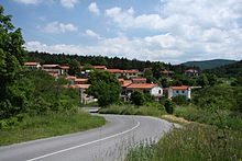
Hrpelje-Kozina
| Hrpelje-Kozina | |||
|
|||
| Basic data | |||
|---|---|---|---|
| Country |
|
||
| Historic region | Coastal land / Primorska | ||
| Statistical region | Obalno-kraška (coast and karst) | ||
| Coordinates | 45 ° 37 ' N , 13 ° 57' E | ||
| surface | 192.2 km² | ||
| Residents | 4,187 (2008) | ||
| Population density | 22 inhabitants per km² | ||
| Post Code | 6240 | ||
| License Plate | KP | ||
| Structure and administration | |||
| Mayor : | Saša Likavec Svetelšek | ||
| Website | |||
Hrpelje-Kozina ( Italian Erpelle-Cosina , German Herpelle-Gossdorf , also: Herpelje ) is a municipality in Slovenia .
geography
The municipality is located in the Primorska region immediately east of the Italian port city of Trieste .
The total community, which consists of 39 villages and hamlets, has around 4187 inhabitants.
traffic
The municipality has a train station on the Divača – Pula line, which was opened in 1876 . From here the Trieste – Hrpelje-Kozina railway branched off in a westerly direction, which was opened in 1887 and closed in 1960. Today a large part of the route has been converted into a cycle path.
Web links
Commons : Hrpelje-Kozina - Collection of images
Individual evidence
- ^ Elmar Oberegger: Hrpelje Railway . In: Obergger2.org , 2006, accessed on October 28, 2016,


