
Huggerwald
| Huggerwald | ||
|---|---|---|
| State : |
|
|
| Canton : |
|
|
| District : | Thierstein | |
| Residential municipality : | Kleinlützel | |
| Coordinates : | 600121 / 252124 | |
| Height : | 601 m above sea level M. | |
 Entrance from (Ober-) Huggerwald |
||
| map | ||
|
||

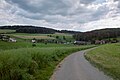
Huggerwald (locally the Huggerwald , formerly also Hoggerwald ) is a hamlet in the municipality of Kleinlützel in the canton of Solothurn , Switzerland .
The agricultural hamlet of Huggerwald is located about 2 km southeast of Kleinlützel and is made up of the
- upper Huggerwald ( location ; also: Ober Huggerwald or simply Huggerwald ) and
- lower Huggerwald ( location ; also: Nieder or Nider Huggerwald )
on the right-hand slope of the Lützel valley . In 1904 there were 24 houses in Huggerwald with 142 inhabitants, all of whom belonged to the Roman Catholic denomination . The place name is to be interpreted as the "forest area of a man named Hugger". In Huggerwald there is a chapel dedicated to Saint Wendelin . Its furnishings include a representation of the Fourteen Holy Helpers on the main altar, various statues from the old parish church of Kleinlützel from 1641 (replaced by a new building in 1924) and an oval painting of the " Immaculata " from the 17th century, originally from the Church of Blauen BL is said to come from.
gallery
View of Nieder Huggerwald

Farm in Nieder Huggerwald

St. Wendelin Chapel


Web links
Individual evidence
- ^ Charles Knapp, Maurice Borel, Victor Attinger, Heinrich Brunner, Société neuchâteloise de geographie (editor): Geographical Lexicon of Switzerland . Volume 2: Emmenholz - Kraialppass . Verlag Gebrüder Attinger, Neuenburg 1904, p. 579, keyword Hoggerwald or Huggerwald (upper and lower) ( scan of the lexicon page ).
- ↑ Huggerwald . In: Markus Gasser, Thomas Franz Schneider (Eds.): The field and settlement names of the Dorneck-Thierstein district (= Solothurn name book ). tape 2 . Schwabe, Basel 2010, ISBN 978-3-7965-2658-9 , pp. 361 .
- ^ Johann Brunner: Kleinlützel . Village history. Jeger-Moll, Breitenbach 1972, p. 113-115 .