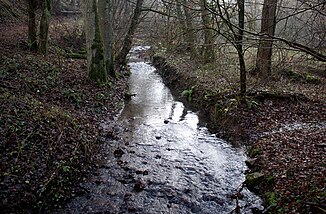
Hundsangen brook
| Hundsangen brook | ||
|
Hundsangener Bach shortly before its confluence with the Lohbach |
||
| Data | ||
| Water code | DE : 25876742 | |
| location | Rhineland-Palatinate , Germany | |
| River system | Rhine | |
| Drain over | Lohbach → Elbbach (Lahn) → Lahn → Rhine → North Sea | |
| source | on the western edge of Hundsangen in the Westerwald 50 ° 27 ′ 31 ″ N , 7 ° 58 ′ 52 ″ E |
|
| Source height | 253 m above sea level NN | |
| confluence | with the Horbach east of Hundsangen to Lohbach Coordinates: 50 ° 27 '36 " N , 8 ° 0' 36" E 50 ° 27 '36 " N , 8 ° 0' 36" E |
|
| Mouth height | 176 m | |
| Height difference | 77 m | |
| Bottom slope | 30 ‰ | |
| length | 2.6 km | |
| Catchment area | 3.83 km² | |
The Hundsangener Bach is the two and a half kilometers long right source brook of the Lohbach in the Rhineland-Palatinate Westerwald . However, some see it only as its tributary.
geography
course
The Hundsangen Bach rises in an industrial zone in the western part of Hundsangen . It initially runs in a south-easterly direction above ground through the village, dips into the underground not far from the Wiesenstrasse and only appears to the east, outside the village, again on the surface. It now turns to the northeast and is fed a little further downstream on its left by a stream coming from the northwest. It now flows first through an alluvial forest , later through a high forest and finally joins directly on the border with Hesse near the Pletschmühle with the Horbach to the Lohbach coming from the north .
