Lohbach (Elbbach)
| Lohbach | ||
|
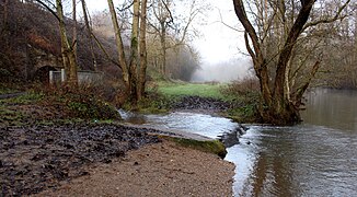
View along the middle and lower reaches of the Lohbach in the Niederzeuzheim district towards the southeast. In the background the Hoheholzkapelle. |
||
| Data | ||
| Water code | DE : 2587674 | |
| location |
Rhineland-Palatinate , Hesse ; Germany |
|
| River system | Rhine | |
| Drain over | Elbbach → Lahn → Rhine → North Sea | |
| origin | The confluence of Hundsangener Bach and Horbach in the Westerwald east of Hundsangen 50 ° 27 ′ 36 ″ N , 8 ° 0 ′ 36 ″ E |
|
| Source height | 176 m above sea level NN | |
| muzzle | on the northern edge of Hadamar in the Elbbach Coordinates: 50 ° 27 '15 " N , 8 ° 2' 43" E 50 ° 27 '15 " N , 8 ° 2' 43" E |
|
| Mouth height | approx. 140 m above sea level NN | |
| Height difference | approx. 36 m | |
| Bottom slope | approx. 13 ‰ | |
| length | 2.7 km (with Horbach 4.42 km) |
|
| Catchment area | 9.069 km² | |
|
Confluence of the Hundsangener Bach (right), the Horbach (left in the foreground) and the Frohnbach (left in the background) to the Lohbach at the Pletschmühle between Hadamar and Hundsangen. |
||
|
The Lohbach flows into the Elbbach on the outskirts of Hadamar. |
||
The Lohbach is a 2.7 km (with Horbach 4.4 km) long right and eastern tributary of the Elbbach in the Westerwald .
geography
Spring streams
The Lohbach arises at an altitude of 176 m above sea level. NN from the confluence of the Horbach and Hundsangener Bach east of Hundsangen near the Pletschmühle in the Westerwald, which already belongs to Hadamar . Some refer to the entire flowing water , including the Horbach , as Lohbach .
Horbach
The Horbach is the 1.7 km long left source brook of the Lohbach .
The Horbach rises in the Rhineland-Palatinate Westerwald northeast of Hundsangen at the foot of the southern slope of the Rauhen Kopf directly on the border with Hesse. Its source lies in a mixed forest at an altitude of 240 m above sea level. NN ( coordinates ). It flows in a south-easterly direction along the borderline between the two federal states and finally unites on Rhineland-Palatinate soil with the Hundsangen Bach coming from the west to form the Lohbach .
Hundsangen brook
The Hundsangener Bach is the right source brook of the Lohbach .
The Hundsangener Bach joins after a run of about 2.6 kilometers with the Horbach coming from the north to the Lohbach .
course
After the union of its two source streams, the Lohbach crosses the border to Hesse and is immediately fed on its left by the Frohnbach coming from the north . The Lohbach now moves in a south-westerly direction, passes the Pletschmühle south of the Gertsberg and then flows through meadows and fallow land. On its shores changes tree plantings, the part is in gallery, partly spreading forest-like, with cabbage hallways and tall herb and the substrate his sole there consists of natural stones and gravel . To the north of the Schnepfenhäüser Hof , it takes on a stream coming from the south on its right, then flows past the fulling mill and finally flows out at an altitude of 140 m above sea level. NN on the northern edge of Hadamar in the Elbbach .
Tributaries
- Horbach ( left source stream ), 1.7 km
- Hundsangener Bach ( right source brook ), 2.6 km
- Frohnbach ( left ), 1.5 km
Elbbach river system
Individual evidence
- ↑ a b c d e GeoExplorer of the Rhineland-Palatinate Water Management Authority ( information )
- ↑ Google Earth
- ↑ Water map service of the Hessian Ministry for the Environment, Climate Protection, Agriculture and Consumer Protection ( information )
- ↑ Name in the city map service


