Wallace line
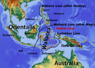
The Wallace Line is the biogeographical line that indicates the furthest extent of Australian fauna in the Malay Archipelago . In the area of the Sunda Islands it runs in the south between Bali and Lombok , in the north between Borneo and Sulawesi . There are two variants for the further course in the area of the Philippine Archipelago : One runs south of the archipelago, one, also known as the Huxley Line , between the main part and the island of Palawan in the west .
The Wallace Line is named after the naturalist Alfred Russel Wallace , who explored the islands between 1854 and 1862, and was named after Thomas Henry Huxley in 1868 . The ornithologist Philip Lutley Sclater was the first scientist to point out the existence and location of this line in 1857 .
Wallacea
The Wallace Line, together with its counterpart, the Lydekker Line , form the borders of the so-called Wallacea , which represents the transition area between the Asian and Australian fauna and thus lies between Orientalis and Australis . The Lydekker line indicates the furthest extent of the Asian fauna in the direction of Australasia and follows the edge of the Australian shelf ( Sahul shelf ). Wallacea covers approx. 346,000 km² and is one of the so-called hotspots , key regions of the world with a very high level of biodiversity , in which animals and plants are in part severely threatened. Very many species both on land and at sea are here endemic , such as Komodo , Timor deer, Hirscheber and tarsier .
Within Wallacea, the Weber line, named after Max Wilhelm Carl Weber , indicates the border to the east of which the Australian forms and to the west of which the Asian forms dominate. It is supported by Ernst Mayr also called equilibrium line. If the Wallacea is not shown separately, for example when the earth is divided into large zoogeographical regions , the Weber line forms the border between Orientalis and Australis.
Emergence
During the last Ice Age the islands of Sumatra , Java , Bali and Borneo , which are on the Sunda pedestal , were in the west with the Asian mainland, and in the east were the islands near Irian Jaya , which are on the Sahul pedestal the Australian mainland. The sea level at that time was due to the establishment of water masses in the ice sheets a maximum of approx. 125 meters lower than today, whereby today's shelf seas formed land bridges. The islands of the Wallacea region were never connected to the mainland and could only be settled by spreading (dispersion) across the ocean. As a result, the fauna in the Malay Archipelago is different.
The discovery by Wallace
Wallace wrote in Lombok , coming from Bali :
“It was here for the first time that I saw many Australian forms, which are completely absent on the islands further west. Small white cockatoos appeared in abundance and their loud screams, their striking white color and their pretty yellow helmets made them an eye-catching feature of the landscape. This is the westernmost point on earth where birds from this family are found. Some small honeysuckers the Ptilotis family and the strange Hügelaufthürmer (Megapodius Gouldii) takes the traveling eastward naturalist here first. […] On the island of Lombok, which is separated from Bali by a strait less than twenty miles wide, I naturally expected to meet some of these birds [from Bali] again; but during a three-month stay there I never saw any of them, but found a completely different series of species, most of which were extremely unknown not only in Java, but also in Borneo , Sumatra and the Malaka peninsula. "
Correspondence in the area of flora
The plant-geographical border, which corresponds to that between the fauna kingdoms of the Orientalis and Australis, is that between the flora kingdoms of the Australis and the Paleotropic . The position of this borderline differs markedly from that of the fauna. Botanically, the Australis only includes mainland Australia and a few nearby islands. The entire arch of islands between Asia and Australia, including the large island of New Guinea, is much more similar in floristic composition to the Asian flora and is accordingly counted as part of the palaeotropic islands.
See also
literature
- Gustaf de Lattin: Floor plan of the zoogeography . G. Fischer, Stuttgart, 1967.
- Alfred Russel Wallace: The Malay Archipelago . Braunschweig, 1869.
- Alfred Russel Wallace: The geographical distribution of the animals . Dresden, 1876.
- Ernst Mayr : Wallace's Line in the Light of Recent Zoogeographic Studies . In: Quarterly Review of Biology . Volume 19, pp. 1-14, 1944; PDF online
Individual evidence
- ^ George Gaylord Simpson (1977): Too Many Lines. The Limits of the Oriental and Australian Zoogeographic Regions . Proceedings of the American Philosophical Society Vol. 121, No. 2: 107-120.
- ↑ On the classification and distribution of the Alectoromorphae and Heteromorphae . In: The Proceedings of the Zoological Society of London , London 1868, pp. 294-319.
- ↑ Mayr, Ernst (2005): Das ist Evolution, page 57, Munich
- ↑ WS Hantoro, H. Faure, R. Djuwansah, L. Faure-Denard, PA Pirazzoli (1995): The Sunda and Sahul continental platform: Lost Land of the Last Glacial Continent. In: SE Asia, Quaternary International 29-30: 129-134. doi : 10.1016 / 1040-6182 (95) 00015-B
- ^ C. Barry Cox (2001): The biogeographic regions reconsidered. Journal of Biogeography, 28: 511-523.

