Iōtorishima
| Iōtorishima | ||
|---|---|---|
| 1978 aerial photo | ||
| Waters | East China Sea | |
| Archipelago | Okinawa Islands | |
| Geographical location | 27 ° 52 '23 " N , 128 ° 13' 38" E | |
|
|
||
| length | 2.7 km | |
| width | 1 km | |
| surface | 2.5 km² | |
| Highest elevation |
方位 212 m |
|
| Residents | uninhabited | |
| Map sketch | ||
Iōtorishima or Iō-Torishima ( Japanese 硫黄 鳥島 , outdated: Iwo-Torishima , German "Sulfur Bird Island "), also Okinawa-Torishima ( 沖 縄 鳥島 ), is a volcanic island of the Ryūkyū island chain with the only active volcano in Okinawa Prefecture .
geography
Iōtorishima is 65 km west of Tokunoshima .
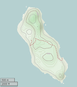
The 2.50 km² island consists of two connected volcanoes made of andesite rock. The southern Gusuku-kazan ( グ ス ク 火山 , "castle volcano") is a lava dome that is located in the center of two Sommas . The northern Iōdake-kazan ( 硫黄 岳 火山 , "sulfur peak volcano") is a stratovolcano whose crater consists of a small lake, solfataras and sulfur deposits. This is still active, with none of the outbreaks having an explosive character. The highest point on the island is the 方位 (probably reading: Hōi) with 212 m, which belongs to the Iōdake-kazan; the highest of the Gusuku-kazan is the Maedake ( 前 嶽 ) with 189.3 m.
history
For centuries, the inhabitants mined sulfur on the island, which the Kingdom of Ryūkyū brought as a tribute to the Empire of China .
The first recorded eruption occurred in 1664, in which a woman died in a landslide. During outbreaks from March to August 1903, all residents were only temporarily relocated to the island of Kume-jima, 220 km away, and with another in June 1958, the settlement with its 86 inhabitants was permanently relocated. The island has been uninhabited since then. In July 1968 there was another outbreak.
Administratively, the island belonged to the village of Gushikawa ( 具 志 川村 , - son ) on Kume-jima , which merged with Nakazato in 2002 to form the city of Kumejima .
Individual evidence
- ↑ a b Creating a cadastral map of Iwo-Tori-shima. In: Ryūkyū Shimpō. July 9, 2011, accessed December 1, 2012 .
- ↑ 沖 縄 県 島 し ょ 別 面積 一 覧 . Okinawa Prefecture, August 24, 2012, accessed November 13, 2013 (Japanese).
- ^ Iwo-Tori-shima in the Global Volcanism Program of the Smithsonian Institution (English)
- ↑ a b 硫黄 鳥島 . In: 海域 火山 デ ー タ ベ ー ス . 海上 保安 庁 海洋 情報 部 (Oceanographic Division of the Coast Guard of Japan ), accessed December 1, 2012 (Japanese).
- ^ Official topographic map of Kokudo Chiriin
- ^ Relocation of Tori Shima Range to Iwo-Tori-shima. In: Ryūkyū Shimpō. June 3, 2011, accessed December 1, 2012 .
- ↑ entry. In: The Significant Volcanic Eruption Database. Retrieved February 27, 2013 .


