Ilhabela
| Ilhabela | ||
|---|---|---|
|
Coordinates: 23 ° 52 ′ S , 45 ° 20 ′ W Ilhabela on the map of Sao Paulo
|
||
|
Location of the municipality of Ilhabela in the state of São Paulo
|
||
| Basic data | ||
| Country | Brazil | |
| State | São Paulo | |
| Residents | 28,196 (2010) | |
| City insignia | ||
| Detailed data | ||
| surface | 347.537 km² | |
| Population density | 81.13 inhabitants / km 2 | |
| height | 1378 m | |
| Waters | Atlantic | |
| Post Code | 11630-000 | |
| prefix | 12 | |
| Time zone | UTC −3 | |
| Website | ||
| View of the Pereque Beach | ||
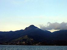
The Ilhabela (Portuguese for "beautiful island") refers to an island in the Brazilian state of São Paulo and the associated archipelago. It is only 4 km from the mainland and lies between São Paulo (distance 200 km) and Rio de Janeiro (distance 340 km). In terms of local politics, it forms the Município da Estância Balneária de Ilhabela .
The actual name of the main island is Ilha de São Sebastião (Portuguese for island of St. Sebastian ), but this is rarely used. The island is an excursion destination, so that in summer there are significantly more than the 26,196 inhabitants named according to the 2010 census. The island can only be reached by ferry from nearby São Sebastião .
geography
The main island of Ilhabela has a largest extension of almost 30 km and an area of about 350 km². That makes Ilhabela the fourth largest Atlantic island in Brazil. The island is home to some of the highest mountains on the São Paulo coast. The highest point is the Pico de São Sebastião with a height of 1379 m and is located in the southern part of the island. Then follow the Morro do Papagaio (1307 m) and the Morro da Serraria (1285 m). Due to its beauty and its position next to the largest flat living space on the island, Pico do Baepi is the most famous elevation on the island, although it is only 7th among the highest mountains of Ilhabela. In addition, the Pico do Baepi peak is the most accessible. At the majority of the elevations there are a large number of waterfalls: 368. Many are easy to reach and allow a pleasant swim in their natural swimming pools (mountain water). Analyzing the format of the island's coastline, one notices the presence of concavities (coves with calm, transparent and emerald green waters) that lead to hidden beaches. The most famous are called “Saco do Eustáquio” and “Saco do Sombrio”, which were considered hiding places by pirates in several attacks in the 17th century. Due to the many capes that can be found on the east coast of the island and which presented a surprising challenge to the merchant and passenger ship commanders, many ships have sunk. In 1914 the Spanish luxury ship “ Príncipe de Asturias ” sank on the “Ponta da Pirabura” in the southeastern part of the island, five minutes after the accident. This shipwreck is known as "the Brazilian Titanic".
The neighboring communities are Caraguatatuba in the north and São Sebastião in the west.
The island has a subtropical climate.
history
Before the colonization of Brazil in the 16th century, the Tupí inhabited the island, which they called Ciribai , which means something like quiet island. On January 20, 1502, Amerigo Vespucci gave the island the name São Sebastião. In the years that followed, the Portuguese established military bases on the coast. Ilhabela has been an independent administrative unit since 1805. From 1938 to 1944, the area was called Formosa before the municipality was given its current name.
tourism

By far the most important branch of the economy is tourism. Ilhabela is known for its beaches with a length of around 36 km, as well as for water sports such as sailing and diving. There are several shipwrecks in the waters around the archipelago, some of which are accessible for diving.
Hikes in the interior of the island are another leisure activity.
fauna
The blue manakin ( Chiroxiphia caudata ) is a living on Ilhabela South American passerine bird.
Ilhabela National Park
By decree nº 9414 of January 20th, 1977 around 78% of the archipelago area was declared Parque Estadual de Ilhabela (PEI).
Web links
- City Prefecture website
- Website of an NGO for the conservation of the Ilhabela
- Tourism site
Individual evidence
- ↑ a b IBGE : Cidades @ São Paulo: Ilhabela . Retrieved April 3, 2014 (Portuguese).
- ↑ Videos, photos and sound recordings on Chiroxiphia caudata in the Internet Bird Collection
- ↑ Chiroxiphia caudata in the Red List of Threatened Species of the IUCN 2013.2. Listed by: BirdLife International, 2012. Retrieved January 30, 2014.
- ↑ Cadastro Nacional de Unidades de Conservação : Parque Estadual de Ilhabela . Retrieved April 3, 2014 (Portuguese).


