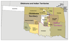
Indian territory
Before Oklahoma was founded, this area in the western United States was the Indian territory . The area extended between 33 ° 35 'and 37 ° north latitude and 94 ° 20' and 98 ° west longitude . It covered about 81,320 km².
history
By the Royal Proclamation of 1763 the settlement area of the European immigrants was limited to the area east of the Appalachians . However, this regulation could not be maintained for long and the settlement border of the Europeans pushed further and further west after the American War of Independence and especially after the Louisiana Purchase and the Adams-Onís Treaty . It was assumed that the areas west of the Mississippi River in contrast to the eastern part were uninhabitable ("Great American Desert"). President Thomas Jefferson planned a settlement zone for Indians in this area. The Mississippi was supposed to separate the immigrants who were supposed to live east of the stream from the indigenous people. Throughout the 19th century , American governments pursued the goal of crowding Native Americans into shrinking territory. President Andrew Jackson was particularly aggressive in the 1830s , under whose administration the Indian Removal Act became law in 1830 , legitimizing the expulsion of all Indians from the territories east of the Mississippi . The relocation took place in a quasi-legal manner. Relocation contracts were officially concluded with the Indians, and no Indian was, according to the wording of the law, forced to give up their homeland.
De facto , however, there was considerable pressure, particularly from the local authorities, and so most of them decided to relocate. However, many felt that they had been betrayed, as some of the contracts had been negotiated by non-authorized persons. The resettlement ran partly under appalling conditions so that, for example, on the Trail of Tears ( Trail of Tears ) of the Cherokee were lost thousands of deaths. The new settlement areas also turned out to be less fertile than the old ones and so there were several Indian revolts that were militarily suppressed.
When, after the Kansas-Nebraska Act in territory 1854 Kansas and Nebraska were formed, only the area now remained Oklahoma as Unorganized territory left, it nationalized the language "Indian territory" for one. The individual tribal governments had limited sovereignty over certain areas that were assigned to the respective Indian nation. The largest and most important were the areas of the so-called Five Civilized Nations :
- Cherokee ( seat of government in Tahlequah )
- Creek or Muskogee ( seat of government in Okmulgee )
- Seminoles ( seat of government in Wewoka )
- Choctaw ( seat of government in Tuskahoma )
- Chickasaw ( seat of government in Tishomingo )
Other Indian peoples from the east, such as the Miami , Delaware or Shawnee , but also indigenous groups such as the Ponca had smaller areas .
Contrary to the promises that the land should belong to the Indians forever, the western part was opened to white settlers in 1889 ( Oklahoma Land Run ) and organized as Oklahoma Territory in 1890 . In the years 1902 to 1905 there were efforts to organize the eastern part of Oklahoma as an independent new state of Sequoyah . However, these efforts met with rejection by President Theodore Roosevelt and in 1907 with the admission of Oklahoma into the Union as a state, the rest of the Indian territory was abolished. This new Oklahoma was administered as a unitary state, the tribal governments lost their sovereign rights.
In July 2020, the Supreme Court ruled the McGirt v. Oklahoma , that this area is still considered an Indian reservation today, also the land on which a large part of Tulsa , the second largest city of Oklahoma, lies. This means that federal jurisdiction applies to criminal law. Shared jurisdiction will be negotiated for civil matters as a result of the ruling between the State of Oklahoma and the Five Tribes.
See also
Web links
Individual evidence
- ↑ Dianna Everett: Indian territory ( Memento of the original from February 25, 2012 in the Internet Archive ) Info: The archive link was automatically inserted and not yet checked. Please check the original and archive link according to the instructions and then remove this notice. . In: Oklahoma's Historical Society's Encyclopedia of Oklahoma History & Culture .
- ↑ Lawrence Hurley: US Supreme Court deems half of Oklahoma a Native American reservation , July 9, 2020
Coordinates: 34 ° 37 ′ 33.6 ″ N , 96 ° 0 ′ 57.6 ″ W.


