Indrawati (Sunkoshi)
| Indrawati | ||
|
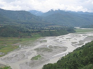
Indrawati near Dolalghat just before the mouth. View from the road bridge of the Araniko Highway upstream. |
||
| Data | ||
| location | Districts kavrepalanchok district , Sindhupalchok ( Nepal ) | |
| River system | Ganges | |
| Drain over | Sunkoshi → Koshi → Ganges → Indian Ocean | |
| source | Langtang Himal region ( Himalaya ) 28 ° 8 ′ 10 " N , 85 ° 39 ′ 8" E |
|
| Source height | approx. 4500 m | |
| muzzle |
Sunkoshi coordinates: 27 ° 38 '9 " N , 85 ° 42' 32" E 27 ° 38 '9 " N , 85 ° 42' 32" E
|
|
| length | approx. 70 km | |
| Catchment area | 1230 km² | |
| Right tributaries | Melamchi Khola | |
| Communities | Melamchi , Bansbari , Bhimtar | |
|
Indrawati in the lower reaches |
||
The Indrawati is a right tributary of the Sunkoshi in the Sindhupalchok district of Nepal .
The Indrawati rises on the southern slope of a mountain range which closes off the Langtang Khola river valley to the south . The headwaters of the river are located within the Langtang National Park . The Indrawati is fed by numerous glaciers. It flows in a predominantly southern direction through the Sindhupalchok district. At the village of Melamchi , the Melamchi Khola meets the river from the right. At Bansbari the Indrawati turns to the south-southeast. It passes Bhimtar and maintains its direction of flow over a length of 20 km to its mouth. He forms the district border to the south Kabhrepalanchok . At Dolalghat the Indrawati finally flows into the Sunkoshi, which flows in from the northeast and then turns towards the south-southeast. The Indrawati has a length of approx. 70 km.

