Ingendorf (Pulheim)
|
Ingendorf
City of Pulheim
Coordinates: 51 ° 0 ′ 30 ″ N , 6 ° 44 ′ 7 ″ E
|
|
|---|---|
| Residents : | 81 (March 31, 2019) |
| Postal code : | 50259 |
| Area code : | 02238 |
|
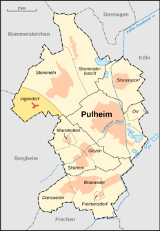
Location of Ingendorf in Pulheim
|
|
Ingendorf is a small hamlet in the town of Pulheim in the Rhein-Erft district in the state of North Rhine-Westphalia .
location
Ingendorf is located in a valley southwest of Stommeln . Büsdorf is located west of Ingendorf . Fliesteden is south of Ingendorf .
history
Ingendorf was first referred to as Ingendorp in 1094. The farms in Ingendorf belonged to the Fronhof association of the Ursulastiftes in Büsdorf. Ingendorf has belonged to the parish of Stommeln since the 15th century . Politically, Ingendorf was part of the Bergheim office in the Duchy of Jülich since the Middle Ages . In 1794 Ingendorf was occupied by French troops and came to the Mairie Stommeln in the canton of Dormagen in the arrondissement of Cologne in the Département de la Roer . From 1815 Ingendorf belonged to the municipality of Stommeln in the district of Cologne . Ingendorf has been part of the city of Pulheim since January 1st, 1975.
Attractions
Iveshof: The current courtyard was built in the 19th century. In 1671 the farm was called Horsterhof and was named after the owner Adam von der Horst . Gut Iveshof is now owned by the Stassen family.
literature
Pulheim contributions to history and local history: community Pulheim, the places and their monuments; Pulheim 1979
Web links
Individual evidence
- ^ Federal Statistical Office (ed.): Historical municipality directory for the Federal Republic of Germany. Name, border and key number changes in municipalities, counties and administrative districts from May 27, 1970 to December 31, 1982 . W. Kohlhammer, Stuttgart / Mainz 1983, ISBN 3-17-003263-1 , p. 301 .


