Advertisement
|
Ins Инзе́р, Большой Инзе́р (Bolshoi Ins), Инйәр |
||
| Data | ||
| Water code | RU : 10010200612111100019478 | |
| location | Bashkortostan ( Russia ) | |
| River system | Volga | |
| Drain over | Sim → Belaya → Kama → Volga → Caspian Sea | |
| source |
Southern Urals 54 ° 18 ′ 5 ″ N , 58 ° 19 ′ 10 ″ E |
|
| muzzle | in the Sim coordinates: 54 ° 14 ′ 12 " N , 57 ° 34 ′ 24" E 54 ° 14 ′ 12 " N , 57 ° 34 ′ 24" E
|
|
| length | 307 km | |
| Catchment area | 5380 km² | |
| Outflow at the Azovo gauge (Bashkortostan) |
MQ |
50.9 m³ / s |
| Right tributaries | Maly advertis | |
| Small towns | Advertisement | |
| Communities | Azovo | |
|
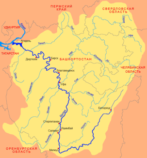
Course of the inser (Инзе́р) in the catchment area of the Belaja |
||
The inser ( Russian Инзе́р , Большой Инзе́р (Bolshoi ins); Bashkir Инйәр ) is a 307 km long left tributary of the Sim in Bashkortostan in the European part of Russia .
It rises on the western slopes of the South Urals . It initially flows in a south-westerly direction, but then turns to the north. In the upper reaches the river is also called Bolshoi Ins ("Big Ins"). At river kilometer 137 at the settlement inser it unites with the right tributary river Maly inser ("little inser") to the real inser. The insert flows into the Sim from the left, 6 km before it flows into the Belaja . The river is ice-covered between mid-November and mid-April. At the level Asowo the average outflow 50.9 m³ / s. The inser drains an area of 5380 km².
Individual evidence
- ↑ a b c articles inser in the Great Soviet Encyclopedia (BSE) , 3rd edition 1969-1978 (Russian)
- ↑ a b Advertisement in the State Water Register of the Russian Federation (Russian)

