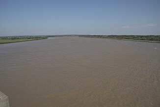
Ishikari (river)
| Ishikari | ||
| Data | ||
| location | Japan | |
| River system | Ishikari | |
| source |
Mount Ishikari 43 ° 32 ′ 0 ″ N , 143 ° 0 ′ 0 ″ E |
|
| Source height | 1400 m | |
| muzzle | Ishikari Bay Coordinates: 43 ° 16 ′ 3 " N , 141 ° 22 ′ 18" E 43 ° 16 ′ 3 " N , 141 ° 22 ′ 18" E |
|
| Mouth height | 0 m | |
| Height difference | 1400 m | |
| Bottom slope | 5.2 ‰ | |
| length | 268 km | |
| Catchment area | 14,330 km² | |
| Drain |
MQ |
113 m³ / s |
The Ishikari River ( Japanese 石 狩 川 , Ishikari-gawa ) is a river on Hokkaidō in Japan . Today it is 268 km long, making it the third longest river in Japan and the longest on Hokkaidō. With 14,330 km² it has the second largest water catchment area in Japan.
The source of the river is on Ishikari Mountain, 1,967 meters high . It then flows through Asahikawa and Sapporo . Important tributaries are the Chubetsu , Uryu , Sorachi and Toyohira .
Until about 40,000 years ago the river flowed into the Pacific at Tomakomai . Lava from the volcanically active Shikotsu Mountains blocked the course of the river, so that it now flows into the Sea of Japan .
The name of the river is derived from an Ainu word that means "winding river". The river once meandered in the Ishikari plain and was as long as the Shinano , now the longest river in Japan. Massive construction work straightened the river and shortened it by 100 kilometers, leaving numerous oxbow lakes in the plain ( 三 日月 湖 ; Mikazukiko , lit. crescent moon lake ).
