Iwol Plateau
| Iwol Plateau | ||
|---|---|---|
|
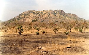
At the foot of the Iwol plateau between Ibel and Bandafassi |
||
| height | 480 m | |
| location | Kédougou , Senegal | |
| Mountains | north of the Fouta Djallon | |
| Coordinates | 12 ° 31 '44 " N , 12 ° 23' 25" W | |
|
|
||
| particularities | List of mountains or elevations in Senegal | |
The Iwol Plateau is located in southeast Senegal in the Kédougou region . It is inhabited by the Bedik ethnic group . Because of the cultural uniqueness of this ethnic group, the entire plateau as part of the Bassari country , cultural landscapes of the Bassari, Fula and Bedik with a core area of 181.47 km² has been included in the list of UNESCO World Heritage since 2012 .
It is a clump-like plateau sloping on all sides with an approximately round shape with a diameter of about ten kilometers and a six-kilometer long extension to the east, which extends to the main town of the rural community Bandafassi. The steep drop of the plateau to the south, which the road from Kédougou to Salémata , the D509, follows, is particularly striking . About 17 kilometers further south, the northern edge of the Dindéfelo highlands rises, which lies on the border between Senegal and Guinea and forms a northern pillar of the rainy Fouta Djallon mountain range.
The steep drop in the south and a ridge branching off from the middle to the north are among the highest peaks in Senegal with a height of up to 480 m .
Since the plateau itself is not named in official maps, a name can primarily be derived from the mountain village closest to the summit, which is called Iwol and is located 1000 meters north of the village of Ibel on the D509 at an altitude of about 400 m . From the north a wooded Kerbtal cuts into the west of the plateau and the less rugged central section of the valley offers settlement areas for other villages that are difficult to access from the outside world.
Individual evidence
- ↑ UNESCO World Heritage Center: Bassari Country: Bassari, Fula and Bedik Cultural Landscapes. Accessed August 21, 2017 .
- ↑ Height according to GeoLocator

