
Jöriseen
| Jöriseen | ||
|---|---|---|

|
||
| View of the Jöriseen from the northwest | ||
| Geographical location | Canton of Graubünden , Switzerland | |
| Drain | Jöribach → Landquart → Rhine | |
| Location close to the shore | Davos , Klosters-Serneus , Susch | |
| Data | ||
| Coordinates | 793 181 / 183928 | |
|
||
| Altitude above sea level | 2489 m above sea level M. | |
| surface | 9.7 ha | |
| length | 520 m | |
| width | 315 m | |
| scope | 1.6 km | |
| Catchment area | 8.5 km² | |

The Jöri (for personal names Jöri for, Georg ') are a group of mountain lakes southeast of Davos and north of Flüelapass in the canton of Grisons in the Swiss Alps . The largest lake is located at an altitude of 2489 m above sea level. M. The Jöriseen are a popular hiking destination in summer.
Location and surroundings

The mountain lakes at the end of the Jörital belong to the Silvretta mountain group and are located in the municipality of Klosters-Serneus ( 1205 m ). In the south they are bordered by the Flüela Wisshorn ( 3085 m ), in the east by the Muttelhorn ( 2825 m ) and in the northwest by the Jörihorn ( 2844 m ) and the Gorihorn / Isentällispitz ( 2985 m ). Access is via the Jöriflüelafurgga ( 2722 m ) in the northwest, the Winterlücke ( 2785 m ) in the southwest, the Jöriflesspass ( 2558 m ) in the southeast or the Jörital in the north.
The Jöriseen are fed with water from the Jöri Glacier , which lies on the northern flank of the Flüela Wisshorn . From the largest lake, the Jöribach flows northwards through the Jörital towards Klosters.
The valley locations are Davos , Klosters-Serneus and Susch . Frequent starting points are Wägerhütta ( 2206 m ) on the Flüelapassstrasse or the Berghaus Vereina ( 1942 m ).
Popular round tour
The Jöriseen are not only one of the top attractions during the summer months for the local Davos Klosters tourism organization. Even Switzerland Tourism describes as the hike "highly recommended". The round tour with start and finish at the PostBus stop Wägerhus / Abzw. Jöriseen advertised on Flüelapassstrasse .
The 11 km circular hike takes around five hours and is more suitable for experienced hikers. From the bus stop, the path leads north-east to the Winterlücke. This is followed by the descent along the left edge of the glacier to the Jöriseen. The way back leads up to Jöriflüelafurgga and from there down into the valley to Wägerhus. The tour can also be tackled in reverse.
Attention: the route between P. 2349 and the winter gap was closed until the end of 2019 due to a rock fall. There was no alternative route. The popular round tour could therefore not be done. It is still unclear whether the access can be reopened in summer 2020.
Access

Summer routes
Via Jöriflüelafurgga
- Starting point: Wägerhütta ( 2206 m ) on the Flüelapassstrasse (Postbus stop Wägerhus / Abzw. Jöriseen)
- Route: Over the Jöriflüelafurgga ( 2722 m )
- Marked as a white-red-white hiking trail
- Time required: 2¼ hours
Via winter gap
- Starting point: Wägerhütta ( 2206 m ) on the Flüelapassstrasse (Postbus stop Wägerhus / Abzw. Jöriseen)
- Route: Over the Winterlücke ( 2785 m )
- Marked as a white-red-white hiking trail
- Time required: 2½ hours
- Note: Access via the winter gap is blocked until the end of 2019 due to the risk of rock falls
From Berghaus Vereina
- Starting point: Berghaus Vereina ( 1942 m )
- Route: Through the Jörital
- Marked as a white-red-white hiking trail
- Time required: 2½ hours
Via Jöriflesspass
- Starting point: Röven ( 1847 m )
- Route: Alp Fless Dadaint, Jöriflesspass ( 2558 m )
- Marked as a white-red-white hiking trail
- Time required: 2¼ hours
gallery
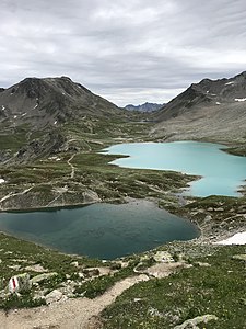
View of the Jöriseen from the northwest (via Jöriflüelafurgga).

Jöriseen, photographed from the Flüela Wisshorn .

In the background the Jörihorn and the Gorihorn / Isentällispitz (right).

View to the northeast towards Jörital.

The largest Jörisee, taken from the northeast.

Flüela Wisshorn , viewed from the Jöriseen.


literature
- National map of Switzerland, sheet 1197 Davos, 1: 25,000, Federal Office of Topography, 2014 edition
Web links
- Jöriseen on schweizersee.ch
- www.hikr.org Various tour reports
Individual evidence
- ↑ Andrea Schorta: How the mountain got its name . Small Rhaetian name book with two and a half thousand geographical names of Graubünden. Terra Grischuna Verlag, Chur and Bottmingen / Basel 1988, ISBN 3-7298-1047-2 , p. 95 .
- ↑ Jöriseen round tour website of the Davos Klosters tourism organization. Retrieved April 14, 2020.
- ↑ Jöriseen round tour website Switzerland Tourism. Retrieved April 14, 2020.
- ↑ Jöriseen round tour website of the Davos Klosters tourism organization. Retrieved April 14, 2020.