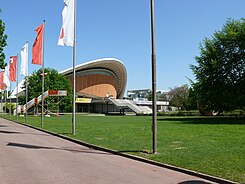
John Foster Dulles Avenue
| John Foster Dulles Avenue | |
|---|---|
| Street in Berlin | |
| View of the congress hall | |
| Basic data | |
| place | Berlin |
| District | Zoo |
| Created | in the 19th century, 1959 |
| Hist. Names |
Zeltenallee (1832–1959) , Schlieffenufer (1934–1959) |
| Connecting roads |
Scheidemannstrasse (east) , Spreeweg (west) |
| Cross streets | Bettina-von-Arnim-Ufer, Große Querallee |
| Places | Tent site |
| use | |
| User groups | Pedestrian traffic , bicycle traffic , car traffic , public transport |
| Technical specifications | |
| Street length | 880 meters |
The John-Foster-Dulles-Allee is an avenue through the Great Tiergarten in the Berlin district of Tiergarten . It runs from the Spreeweg and flows into Scheidemannstrasse near the Reichstag building . It is named after the former US Secretary of State John Foster Dulles .
history
The original course of the former Zeltenallee ran from Kurfürstenplatz to Friedensallee (today: Simsonweg ), near the Brandenburg Gate . "In den Zelten" was a popular excursion destination with many beer tents and events, especially at the tent site . Only half of the current route has been preserved; John-Foster-Dulles Allee ends on the west side of the Soviet memorial . The Zeltenallee was built over at the height at which it crossed the Siegesallee .
In 1959 the name was changed to John-Foster-Dulles-Allee. In addition, the part of the former Schlieffenufer (from the Spreeweg to Kurfürstenplatz) was renamed. The best-known building on the avenue is the congress hall with the House of World Cultures .
Web links
- John Foster Dulles Avenue. In: Street name lexicon of the Luisenstädtischer Bildungsverein
Coordinates: 52 ° 31 '3.5 " N , 13 ° 21' 44.5" E
