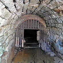
König-Wilhelm-Stollen (Egestorf)
The König-Wilhelm-Stollen , also known as the main tunnel , railway tunnel or railway tunnel , is a former mine tunnel in the Deister near Egestorf in the Hanover region . Today the tunnel is protected as a natural monument.
history
There is evidence of a coal mine in operation in the Deister as early as 1639. In the 19th century there were many places to plant new mines to promote in to cm to 100 powerful coal seams encountered Wealdenkohle .
In the first digging attempts in the years 1816 to 1819, only a 12 to 15 cm thick, hanging seam was encountered in the private forest district of Kniggenbrink in the Deister south of Egestorf, which is why there was no coal mining.
Royal studs
In 1844, the baron had Knigge in the higher part of the etiquette Brinks build a mine to a found there 45 to 55 cm thick, lying seam coal to win . ▼ To keep up with the seam falling to the north-northeast, three tunnels were built on the western edge of the Kniggenbrink forest district. The Kniggesche Stollen No. IV, however, was on the other edge of the Kniggenbrink near the state Sürsserbrinker König-Wilhelm-Stollen . The number of employees rose to 155 miners by 1861, who mined 24,938 t of coal.
Railroad adit
In the years 1860 and 1861, about 1.2 km east of the first tunnel, an additional tunnel of the Kniggenbrinker hard coal mine about 70 meters lower was excavated in order to reach lower lying coal fields . The officially called main tunnel , 870 m long up to the seam, made it possible as a new main conveyor tunnel to increase production to 33,481 t of coal in 1868.
In the course of planning a railway line in the area in 1860, the industrialist Georg Egestorff advocated a route across Georgsplatz . The colliery site at the main tunnel would have been on the route from Georgsplatz to Barsinghausen . On the other hand, according to an information board on the coal path, the common names railway tunnel or railway tunnel emerged because a horse-drawn tram was used to transport the coal to Georgsplatz. It was not until 1872 that the Deisterbahn was opened with the Egestorf station about 1.2 km north of the tunnel.
The personal-consuming construction of primarily as a water release tunnel serving depths Knigge Brinker tunnel up to the then outskirts of Egestorf took place in 1868. ▼ Nevertheless, it came in the 1880s to repeated water release issues , so in the meantime new owner to operate the mine abandoned for lack of income.
King Wilhelm Stollen
The coal mining rights of the Kniggenbrinker hard coal mine were taken over by the Prussian state in 1890 . A breakthrough to the Egestorf tunnel of the state coal mine in the Stockbachtal valley had already been breached in 1887 .
The tunnels, shafts and the main conveying line of the mine were modernized and the production via the former railway tunnels was resumed. He has now King Wilhelm Stollen called, thus the name of the 1891 disused neighboring King Wilhelm tunnel in the district Wennigsen was acquired. In 1895/6, the production of the 126 miners increased to 14,801 t of coal, but fell in the following years. In 1901, which was promoting the new King Wilhelm studs set.
Natural monument
The mouth of the new König-Wilhelm-Stollen has been partially bricked up since it was repaired in the 1980s. The tunnel is protected as a natural monument under the number ND-H 157 . It is considered to be "unique in Lower Saxony in terms of number and biodiversity" winter quarters for bats and amphibians with great importance for the conservation of bats as well as for science, natural history and local history.
Others
In 1880, 126 of the 291 miners from the various state mines and others from the Kniggenbrink mine lived in Wennigsen. In order to shorten the long way to work, from 1875 some of them built houses on the outermost boundary between Wennigsen and Egestorf. Today's Wennigser district of Wennigser Mark arose from this miners' settlement.
See also
literature
- Friends of the visitor mine Barsinghausen (Hrsg.): The Deister coal paths . Barsinghausen 2014, without ISBN. Pp. 104-107
Web links
supporting documents
- ↑ a b c d e Egestorf: Mining. www.barsinghausen.de, accessed on February 22, 2017 .
- ↑ a b Information board Kniggenbrinker Steinkohlenbergwerk of the Förderverein Visitor Mine Klosterstollen Barsinghausen e. V. at the mouth of the main tunnel, as seen on September 3, 2016
- ↑ Information panel mining in the area of Georgsplatz , the garden region of Hanover at Georgsplatz, as seen on September 3, 2016
- ↑ Appendix 1 to the 19th Ordinance on Natural Monuments of the Hanover Region (New Regulation Ordinance). in Common Official Gazette for the Hanover Region and the State Capital Hanover - special edition . Hanover region, September 7, 2010, accessed on March 15, 2015 .
Coordinates: 52 ° 16 ′ 15.3 " N , 9 ° 30 ′ 42.2" E

